JAKARTA - With a history of about 2000 years, the Government of Saudi Arabia is trying to add the ancient underground aqueduct of Firzan, as the seventh site on the UNESCO World Heritage Site list.
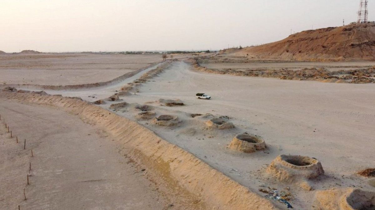
Located in the northwest of Al-Kharj Province, the well over 7,000 meters long canal is used to carry underground water from mountains in the neighboring province to agricultural areas.
"No one knows exactly where the name 'Firzan' came from, because it is a very old name," explains Dr. Farhan Al-Juaidi as quoted by Arab News 10 August.
"But the nearby mountain, where the water source is, is also known by the same name," continued the professor of geography at King Saud University, Saudi Arabia.
The irrigation system has been known for thousands of years and this particular canal is 2,000 years old, he said.
"The ancient water canal, which stretches over an area of almost 7 kilometers, and the discovery of more than 5,000 ancient pagan graves, dating from pre-Islamic and even pre-Christian eras, were found near Mount Firzan, provide us with evidence of human presence in the cities. which may have been buried."
Further evidence of the history of the area can be found in several poems from the pre-Islamic era. Al-Juaidi said this particular irrigation system was built underground, as those who use it clearly realize the water will evaporate if it is transported above ground.
"This irrigation system is one of the most important traditional irrigation engineering systems known to man. In that system, water is drawn from springs or wells through underground horizontal channels to irrigate agriculture far from water sources," explained Al-Juaidi.
He further explained that several water wells along this channel could also help provide more water for the people and their crops, which they rely primarily on as a source of food.

Al-Juaidi, who wrote a book about the region, said there was a chain of 150 holes ranging in depth from 25 to 20 meters.
"The depth of these holes gradually decreases from the water source to the mouth of the channel, which is almost 50 centimeters deep (at the mouth of the channel). The wells in the canal are between five and six meters apart, with a mouth diameter ranging from one to four meters What distinguishes the Firzan canal from the canal in Al-Ula or Al-Asyah is that the hole in this canal is deeper, and the canal itself is even longer than other water canals in the kingdom," he said.
Al-Juaidi said he had spoken about the characteristics of the canal with the CEO of the Heritage Authority, Dr. Jasir Al-Herbish.
"Al-Herbish expressed the interest of his authorities in developing and preserving the site. We actually hope this site will be listed in the UNESCO World Heritage Site list," said Al-Juaidi.
Added by the King Abdulaziz Archives and Research Foundation (Blood) has conducted a landmark study to document the site of canals and graves at flat elevations near Mount Firzan. In its documentation, Blood records the location coordinates, size and cadastral survey of the place. It also shoots canals.
"The last Firzan aqueduct restoration project was in the era of King Abdul Aziz and continued into the 1950s. However, some wells are now filled with garbage and sewage. Therefore, I suggest an immediate intervention to restore the site and seek to register it with UNESCO," said Al -Juaidi.
SEE ALSO:
To note, in his book Al-Juaidi wrote how the region attracted many Western travelers and researchers who visited the region, including Glen Brown, John Philby, Gerald de Gaury, and Daniel van der Meulen.
Based on his previous geological experience in the United States (US) and abroad, Brown was selected in 1944 to investigate the water supply in the Saudi desert in response to the late King Abdul Aziz's request for assistance from the US Geographical Survey.
The English, Chinese, Japanese, Arabic, and French versions are automatically generated by the AI. So there may still be inaccuracies in translating, please always see Indonesian as our main language. (system supported by DigitalSiber.id)


