

MALUKU - Tanimbar Islands Regency and Southwest Maluku Regency, Maluku Province, were rocked five aftershocks with varying strengths on Wednesday, November 8.
"The first earthquake with a magnitude of 7.2 occurred at 11.52 WIB," said Maluku BPBD Head of Emergency and Logistics Sandy Luhulima in Ambon, Antara, Wednesday, November 8 evening.
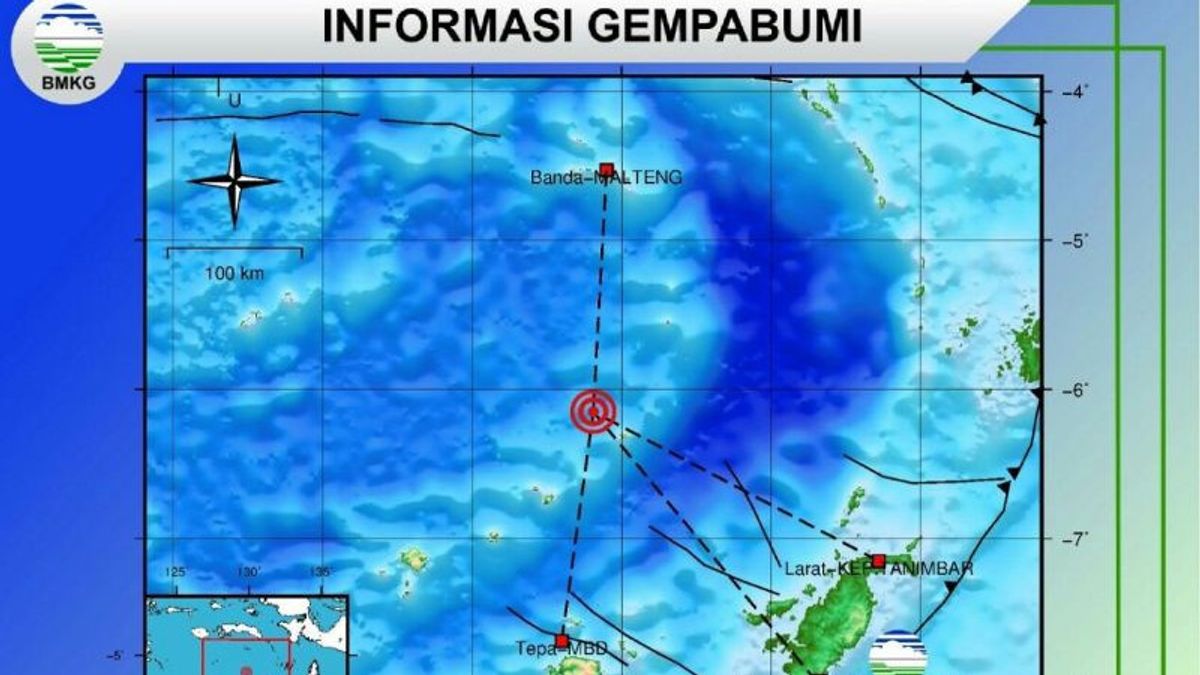
BMKG said the earthquake was centered at sea, precisely at 6.31 South Latitude (LS) and 129.77 East Longitude (BT) or 251 km northwest of Tanimbar, Tanimbar Islands Regency at a depth of 10 km.
Aftershocks with a magnitude of 5.2 10 km at 13.06 WIT, coordinates 6.21 LS-129.89 East Longitude (251 km northwest of Tanimbar), have no potential for a tsunami.
Aftershocks with a magnitude of 5.6 at 14.30 WIT at a depth of 12 km. The epicenter of the earthquake at the location of 6.28 LS-129.14 East Longitude is about 164 km north of Tepa (Babar Island), Southwest Maluku Regency or 212 km southwest of Banda Island, Central Maluku Regency.
At 14:42 WIT there was an aftershock with a magnitude of 5.6 at a depth of 10 km with an epicenter at the location of 6.15 LS-129.81 East Longitude about 172 km north of Tepa (Babar Island), Central Maluku Regency or 181 km south of Banda Island, Central Maluku Regency.
A total of two other aftershocks with magnitudes 4.7 and 4.8 occurred a few minutes later, but the BMKG said there was no potential for a tsunami.
"We are still coordinating with the Satlak PB of MBD Regency (West Maluku) regarding the possible impact of today's earthquake damage," he said.
He said the initial report from Satlak PB MBD stated that residents of the Wetang area felt the most earthquake shocks, while in East Babar District it was relatively safe.
SEE ALSO:
-
 | BERITA
Besok Pukul 09.00 WIB, Mahkamah Konstitusi Gelar Pemilihan Ketua Baru Pengganti Anwar Usman
08 November 2023, 16:27 -
 | BERITA
Dipecat dari Ketua MK, Anwar Usman: Ada Skenario untuk Membunuh Karakter Saya
08 November 2023, 15:19 -
 | BERITA
Sebut Prabowo-Gibran Ada di Hati, Bobby Nasution: Mudah-Mudahan 'Aman Ini Barang Pak'
08 November 2023, 15:34


The English, Chinese, Japanese, Arabic, and French versions are automatically generated by the AI. So there may still be inaccuracies in translating, please always see Indonesian as our main language. (system supported by DigitalSiber.id)
Add VOI as a Preferred Source
Follow VOI news updates across Google.
+


