

JAKARTA – Google Research, a research center that focuses on conducting scientific research, collaborated with Muon Space and the Environmental Defends Fund in creating FireSat, a constellation of forest fire detection satellites.
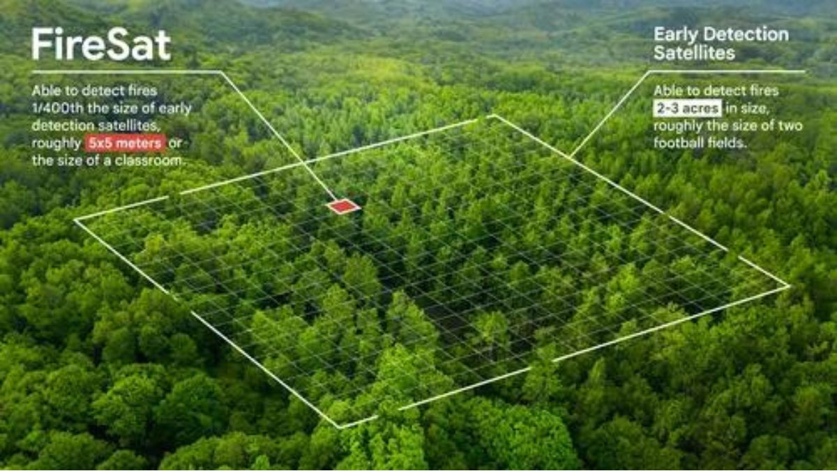
FireSat is designed to quickly detect small fires the size of a classroom or around 5 x 5 meters. Data from this satellite will be updated globally every 20 minutes to help firefighters in conducting early detection.
FireSat's infrared sensor uses high-resolution imagery to detect and track forest fires precisely. This satellite is also supported by Artificial Intelligence (AI) technology to combine local weather factors and nearby infrastructure.
"To validate our detection model for smaller fires and establish a baseline dataset for AI, we will fly sensors over controlled fires," said Google on its official website.
SEE ALSO:
-
 | TEKNOLOGI
Jabar Sabet Emas untuk Cabor Esports Free Fire di PON XXI Aceh-Sumut 2024
16 September 2024, 09:18 -
 | TEKNOLOGI
Huawei Siap Tingkatkan Akses Pengisian Daya Kendaraan Listrik di Indonesia
16 September 2024, 08:33 -
 | TEKNOLOGI
Potensi Pengobat dengan Sel Punca Besar, Perlu Protokol Keamanan Ketat
14 September 2024, 16:40


The first FireSat satellite will be launched by Muon Space in early 2025 and the constellation will be completed in the next few years. After launch, the satellite will provide information on the location, size, and intensity of fires.
"In addition to supporting emergency response efforts, FireSat data will be used to create a global historical record of fire spread, which helps Google and scientists to better model and understand the behavior and spread of wildfires," explained Google.
FireSat is an initiative led by the Earth Fire Alliance, a non-profit organization to launch the FireSat constellation. This institution also receives support from the Moore Foundation. The creation of this constellation will be funded by Google.org for 13 million US dollars (IDR 199 billion).
The English, Chinese, Japanese, Arabic, and French versions are automatically generated by the AI. So there may still be inaccuracies in translating, please always see Indonesian as our main language. (system supported by DigitalSiber.id)
Most Popular Tags
#Prabowo Subianto #donald trump #2026 World Cup #venezuela #konflik timur tengahPopular


