

The Military Resort Command (Korem) 032/Wirabraja continues to alert a number of its soldiers to anticipate the impact of the eruption of Mount Marapi in Agam Regency and Tanah Datar Regency, West Sumatra (West Sumatra).
"Korem 032 Wirabraja through the units below will continue to alert the troops for the rapid reaction to handling natural disasters," said Commander of Korem 032/Wirabraja Brigadier General (Brigjen) Rayen Obersyl in Padang, Wednesday, March 27, as reported by Antara.
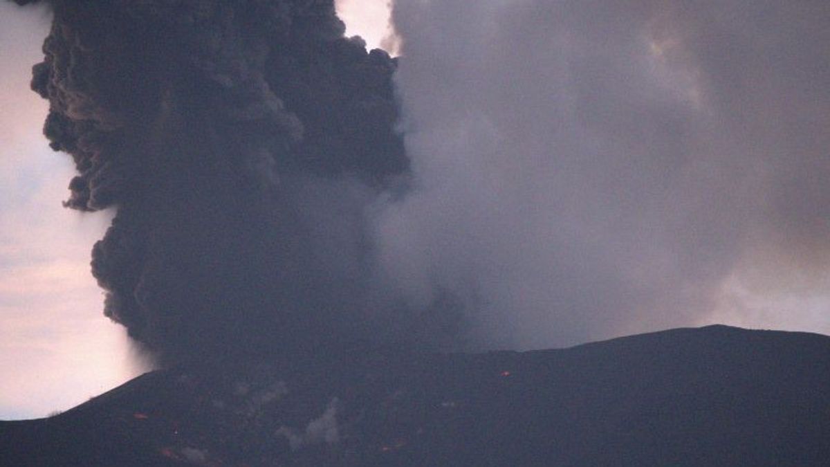
This was conveyed by Rayen in response to the condition of Mount Marapi after the eruption on Wednesday, March 27 at 00.13 WIB. At that time, the eruption of Marapi ejected a column of ash about 1,500 meters high.
Rayen Obersyl said he had also coordinated directly with the Center for Volcanology and Geological Hazard Mitigation (PVMBG) regarding the current condition of the volcano.
Based on the PVMBG report, there has been no increase or change in status. In other words, currently Mount Marapi is still Level III or on standby.
He added, if the impact of the volcanic eruption is still within a radius of 4.5 kilometers, it is still relatively safe for the community. However, what is feared is that it has crossed the 4.5 kilometer limit and has the potential to endanger local residents.
SEE ALSO:
-
 | BERITA
Ganjar-Mahfud Minta Pilpres Diulang Tanpa Prabowo-Gibran Paling Lambat 26 Juni
27 Maret 2024, 13:55
Separately, the Mount Marapi Volcano Observation Post reported that the eruption of Mount Marapi on Wednesday morning at 00.13 WIB with a column height of ash was observed to be about 1,500 meters above the peak.
The ash column is observed to be gray with thick intensity and leaning towards the west. The eruption was recorded on a seismograph with a maximum amplitude of 38.7 millimeters, and a temporary duration of about 1 minute 45 seconds.
One of the PVMBG recommendations related to the condition of Mount Marapi is that people around the mountain, climbers or tourists are advised not to enter or carry out activities within a radius of 4.5 kilometers (km) from the eruption center aka Verbeek Crater.
The English, Chinese, Japanese, Arabic, and French versions are automatically generated by the AI. So there may still be inaccuracies in translating, please always see Indonesian as our main language. (system supported by DigitalSiber.id)
Most Popular Tags
#Prabowo Subianto #donald trump #Febrie Adriansyah #8791 #giias 2026Popular


