

SUMBAR - All parties are asked to comply with the recommendations of the Center for Volcanology on Geological Hazard Mitigation (PVMBG) related to the eruption of Mount Marapi. The appeal was conveyed by the Geological Agency of the Ministry of Energy and Mineral Resources (ESDM).
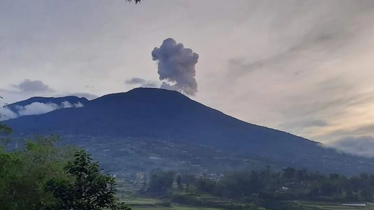
"The Marapi Hamlet has experienced an eruption with a column height of ash observed 800 meters from the peak on December 4, 2023 at 22.00 WIB. The ash column was observed to be gray to black thick intensity leaning towards the southwest. This eruption was recorded on a seismogram with a maximum amplitude of 3 mm with a duration of approximately 1 minute 8 seconds," said Acting Head of the Geological Agency Muhammad Wafid during a press conference related to the 'Development of West Sumatra Volcano Activities' in the release of the Ministry of Energy and Mineral Resources, confiscated by Antara.
The mountain in West Sumatra (West Sumatra) is now in alert status or Level II. Residents around Mount Marapi and tourists are no longer allowed to approach a radius of 3 km from the crater for mutual safety.
"PVMBG has issued recommendations regarding the volcanic activity of Mount Marapi and has been informed to related parties, including local governments, to comply," he also said.
Head of PVMBG Hendra Gunawan explained that Mount Marapi (2,981 meters) administratively located in Agam Regency and Tanah Datar Regency.
"The Marapi Monument is monitored visually and instrumentally from the Gunungapi Observation Post (PGA) located on Jl Prof. Hazairin No. 168 Bukittinggi, West Sumatra Province," he said.
SEE ALSO:
-
 | BERITA
Sudah 8 Jam di Polda Metro, Aiman Masih Diperiksa Terkait Pernyataan 'Polisi Tidak Netral'
05 Desember 2023, 18:06 -
 | BERITA
Sindir Gibran, Anies: Asam Folat Didapat dari Tanaman, Bukan di Bengkel
05 Desember 2023, 12:49 -
 | BERITA
Ternyata Menparekraf Sandiaga Punya Kebiasaan Seruput Kopi Susu Tanpa Diaduk
05 Desember 2023, 10:08 -
 | BERITA
Polda Metro Dikabarkan Geledah Apartemen Firli Bahuri di Darmawangsa Jaksel
05 Desember 2023, 13:11
According to Hendra, the nature of the eruption of Mount Marapi is very difficult to detect, even visual observations on October 14, 2023, in the active crater of Mount Marapi, there is no visible volcanic activity, thus making his party and the mountain community feel safe, because there is no visible volcanic activity whatsoever.
"This is very dangerous, silent like that. Therefore, the relationship is why there is a Level II status, which means it is more preventive, because visually it is okay and in terms of seismicity there may only be one earthquake per month," he said.
Hendra continued, considering that the history of the eruption often occurs, PVMBG issued a recommendation of 3 km from the crater based on statistics of eruptions every 2 to 4 years, only the date and month could never be known.
"Rekomendasi masyarakat tidak aktivitas apa pun dalam radius 3 km dikeluarkan PVMBG mengambil skenario terburuk, karena berdasarkan statistic kejadian 3 km merupakan jarak terdampak. Dampaknya itu selalu di sekitar puncak dan itu sebenarnya buffer buat kita untuk diyakin aman dan kami berharap semua pihak mematuhi ini," ujar Hendra.
The English, Chinese, Japanese, Arabic, and French versions are automatically generated by the AI. So there may still be inaccuracies in translating, please always see Indonesian as our main language. (system supported by DigitalSiber.id)
Most Popular Tags
#Prabowo Subianto #donald trump #2026 World Cup #Febrie Adriansyah #8791Popular


