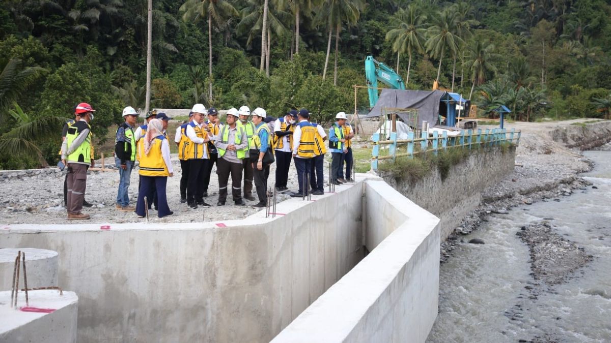


JAKARTA - The Ministry of Public Works and Public Housing (PUPR) through the Sulawesi III River Basin Center (BWS) Palu is currently handling the Palu, Kawatuna, and Ngia rivers.
This handling was carried out to anticipate flooding in Palu City, Central Sulawesi.
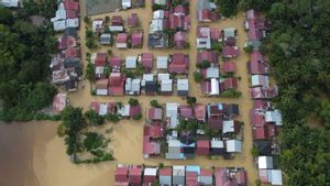
The earthquake that occurred on September 28, 2018 in Palu City caused landslides at several hilly points in the Palu River Basin, most of which occurred in Sigi Regency, causing sediment to enter the river body. In addition, sediment that occurs in the river body is also caused by erosion of river cliffs.
Head of the Sulawesi III River Basin Center (BWS) of the Ministry of PUPR Dedi Yudha Lesmana said the sediment on the river body resulted in a flash flood disaster in 2019.
The combination of high sedimentation and high rainfall for 2 to 8 hours per day causes heavy flooding in Palu City.
"For this reason, the Ministry of PUPR through the Sulawesi III Palu River Basin Center will carry out Long Term (Long Term) handling and sediment control in Palu City by construction of river embankments, controlling river base elevations (Groundsil), and consolidating dams which are one type of sediment control building and balancing the river's base slope," said Dedi in a written statement, Thursday, December 14.
Dedi said the construction of flood control in the three rivers in Palu City had started in August 2023 with funding sources from the Loan Japan International Cooperation Agency (JICA).
The construction was carried out by PT Selaras Mandiri Sejahtera with a contract value of IDR 150 billion.
He added that the scope of handling the Palu River itself includes the construction of a 387 meter (m) river embankment on the left and 364 meters on the right.
"In addition, a 487-meter-long coastal embankment was also built on the left and 423 meters on the right, as well as the dredging of 800-m long river sediment," he said.
Meanwhile, the handling of the Kawatuna River, said Dedi, is being carried out by the construction of a consolidation of two units with a length of 40.5 meters and a height of 6 meters, respectively.
"In the Kawatuna River, six units of landsil were also built with a length of 17.7 meters and the safety of river cliff erosion (revetment)," he said.
Finally, in the Ngia River, three units of dam consolidation is being built, of which one unit is 25.5 meters long and the other two units are 21 meters long.
Not only that, the groundsil was also built which was used to reduce the slope of the river current so that the water speed became small and the water depth increased.
SEE ALSO:
-
 | BERITA
Waspada Cuaca Ekstrem, 38 Persen Wilayah di Indonesia Masuk Musim Hujan
13 Desember 2023, 08:15


For your information, the Palu River is the primary river for the Palu-Lariang watershed. The downstream part of the Palu River was badly damaged by the earthquake and tsunami.
Then, the Kawatuna River is a tributary of the Palu River that passes through the airport runway due to the 2018 earthquake. Thus, flooding with sediment often occurs and settles in culverts under the airport runway.
Meanwhile, the Ngia River, which is associated with irrigation canals when it rains heavily, carries very high sediments, and can endanger airport infrastructure and irrigation canals.
The English, Chinese, Japanese, Arabic, and French versions are automatically generated by the AI. So there may still be inaccuracies in translating, please always see Indonesian as our main language. (system supported by DigitalSiber.id)
Most Popular Tags
#Prabowo Subianto #donald trump #2026 World Cup #bgn #konflik timur tengahPopular


