JAKARTA - Shocking satellite images have revealed the extent of the damage caused by wildfires as a heatwave swept through western Europe this week.
The images were taken by the European Space Agency (ESA) via the Copernicus Sentinel-3 satellite, which orbits 506 miles (814.5 km) above the Earth's surface. These satellites work to measure the condition of our planet's oceans, land, ice and atmosphere.
Photographs taken in France's southern Gironde region on July 12 and July 17 show smoke and swathes of scorched earth, highlighting the extent of damage caused by heatwave bushfires.
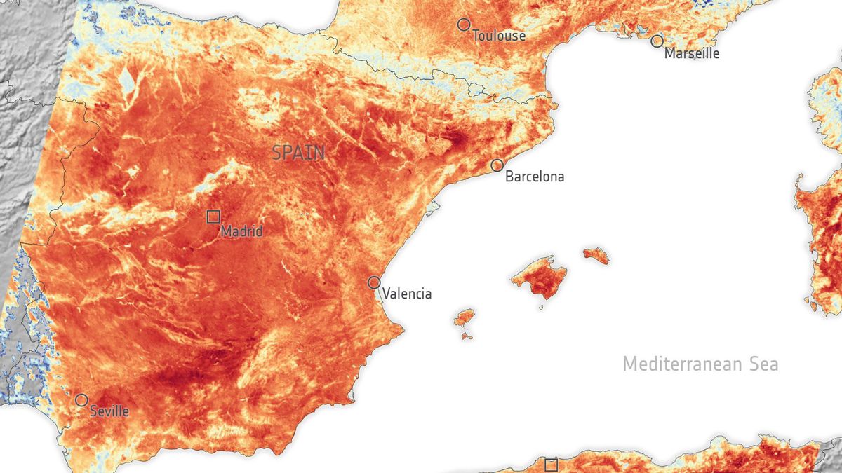
The ESA also released a heat map showing ground surface temperatures in southern France, Spain and northern Africa on the morning of July 17.
France, Spain, Morocco and Algeria land-surface temperature on 17 July 🥵🌡️
(data acquired in the morning)
As this @CopernicusEU #Sentinel3 map shows, the current #heatwave is all too apparent, even from space.
ℹ️https://t.co/hrKzYKlJnV pic.twitter.com/Db6IRJ6OuB
— ESA EarthObservation (@ESA_EO) July 20, 2022
"In some places the ground level reaches 55°C [131°F]," the European Space Agency explained, in its blog quoted by the Daily Mail. "Given that Copernicus Sentinel-3 obtained this data in the morning, temperatures will increase during the afternoon and into the evening."
Air temperature is a measure used for daily weather forecasts, and is a measure of how hot the air is above the ground. However, ground surface temperature is a measure of how hot the ground surface actually is to the touch.
"Scientists monitor ground surface temperatures because the warmth rising from the Earth's surface affects weather and climate patterns," the ESA added. "This measurement is also very important for farmers evaluating how much water their crops need and for urban planners looking to improve heat mitigation strategies,"'
In the soil surface temperature image, the area indicated in dark red has a soil surface temperature of up to 55°C [131°F].
In a set of satellite images taken on July 12 and July 17, the "wounds" left by forest fires around the commune of Guillos and near the town of Cazaux in southwestern France can be seen.
"On July 12, 2022, two large forest fires occurred in southwestern France," the ESA said. “The forest fires have severely affected local communities: more than 16.000 people have been evacuated in total, and road closures have been imposed. Even though there was a big fire but no casualties have been reported.”
The Copernicus Sentinel-2 satellite carries innovative wide swath high-resolution multispectral imagery with 13 spectral bands. It provides a new perspective on soil and vegetation on Earth, according to the ESA, with its short-wave infrared channel used to highlight heat from forest fires.
In another side-by-side image taken on July 12 and July 17, burn marks and an active fire can be seen near La Teste-de Buch in southwestern France, where the bushfires reach to the shoreline.
"The Copernicus Emergency Management Service has been activated to respond to the many fires currently ravaging Europe, including those impacting the Gironde," the ESA said.
VOIR éGALEMENT:
"The service leverages observations from multiple satellites to provide on-demand mapping to assist civil protection authorities and the international humanitarian community in dealing with major emergencies," the ESA added.
Apart from France, Spain and the UK are also experiencing severe forest fires amid the heatwave.
On July 17, a fire broke out near Losacio in the Province of Zamora in the Spanish autonomous region of Castilla y Léon.
This image taken by Copernicus Sentinel-2 on July 18 shows clouds of smoke and active fire from the Losacio forest fires as well as scars from the Sierra de la Culebra fires.
Heat warnings are still in effect in many parts of Europe, while drought warnings are in effect in half of the EU bloc.
"As the effects of climate change increase, the fear is that this kind of extreme weather will also increase," the ESA concluded.
“Satellites orbiting the planet play a critical role in transmitting data to understand and monitor how our world is changing – data that is key to mitigation strategies and policy making,” said the ESA.
The English, Chinese, Japanese, Arabic, and French versions are automatically generated by the AI. So there may still be inaccuracies in translating, please always see Indonesian as our main language. (system supported by DigitalSiber.id)


