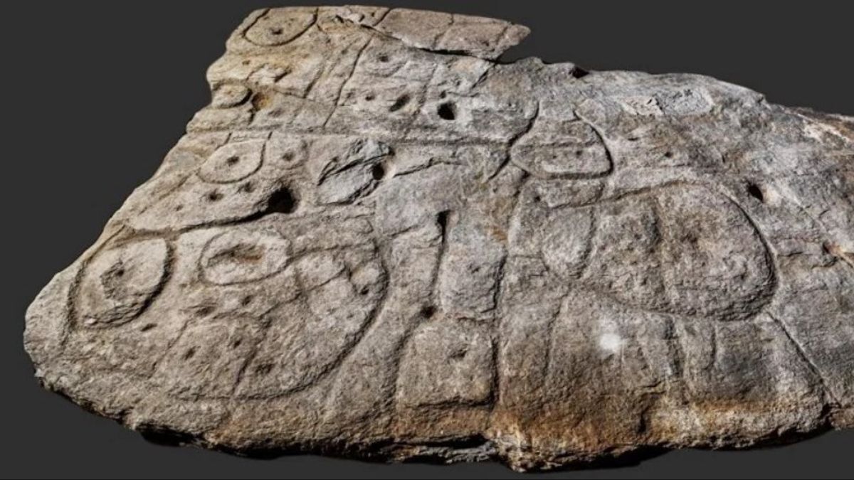


JAKARTA – Researchers found a stone map believed to date back to the Bronze Age. The stone depicts the oldest three-dimensional map in continental Europe.
For the first time, a stone slab measuring 2 x 1.5 meters was found in 1900. Then in 2014, the stone slab was again found in France. In a castle basement to be precise.
Archaeologists studied various carved patterns found on the 4.000-year-old stone. They revealed that the stone plate was a map in the western Britanny region of France.
The archaeologists stated that the stone plate was the oldest three-dimensional map ever found in Europe. The stone plate was named Saint-Bélec Slab. They believe the stone dates back to the early Bronze Age, around 1900 to 1650 BC.
It was Paul du Chatellier who first discovered the stone in 1900. At that time there was an excavation of a prehistoric grave complex in a place called Finistère which was part of Brittany.
After that, the stone plate was forgotten for a century. The three-dimensional map stone is stored under a moat near Chatellier's home, the Château de Kernuz.
In 2014, archaeologists found the stone in the basement of a castle. The researchers analyzed the stone and they concluded that it was an ancient map.
The "repeated motive combined with the line" on the surface of the stone slab proves that it is a map of finistère territory, as reported by the French Prehistoric Society.
SEE ALSO:
-
 | BERITA
Temuan Arkeologi Terbaru Berusia 3.000 Tahun Bisa Ubah Sejarah Saqqara
23 Januari 2021, 10:29

They reveal that the carvings on the stone are three-dimensional representations of the Odet River valley. The other lines on the rock are described as the flow of the river that existed at the time. The map of the stone plate has an accuracy rate of 80 percent.
"This is probably the oldest map of an area that has been identified", said the head of the research team, Dr. Clément Nicolas as quoted by the BBC.
"There are several maps carved on rocks around the world. Generally, it's just an interpretation. But this is the first time a map has depicted an area on a certain scale", he added.
He said the map was likely used as a marker of territorial ownership.
"This map is likely an attempt to assert ownership of a particular territory by a prince or king at the time".
Nicholas also revealed that the tendency of people living in modern times often underestimates the knowledge possessed by the people of the past.
"We tend to underestimate the geographical knowledge of people in the past. This slab is important because it highlights this cartographic knowledge", he concluded.
The English, Chinese, Japanese, Arabic, and French versions are automatically generated by the AI. So there may still be inaccuracies in translating, please always see Indonesian as our main language. (system supported by DigitalSiber.id)
Most Popular Tags
#Prabowo Subianto #golkar #Pilkada Dki #online gambling #Mount Lewotobi malePopular