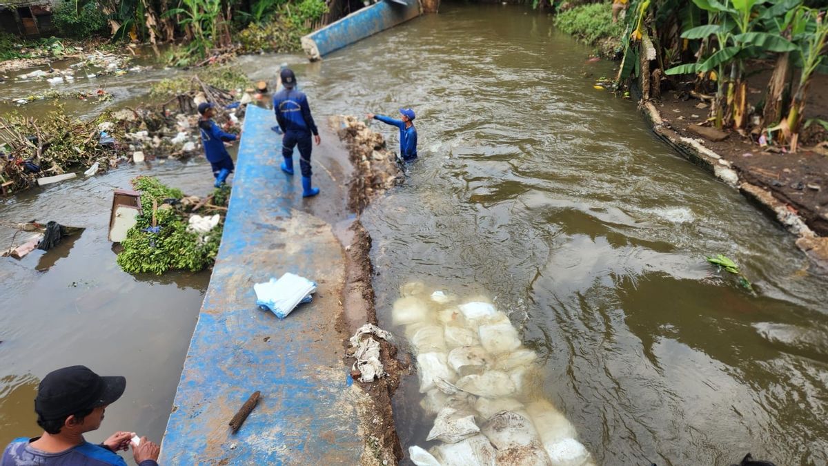


JAKARTA - The DKI Jakarta Water Resources Agency noted that the collapse and landslide occurred on eight embankments in Jakarta when heavy rains hit Jakarta almost every day from Thursday, October 30 until now.
More specifically, as many as 5 embankments collapsed and 3 landslide embankments, all of which were in South Jakarta. Secretary of the DKI Jakarta SDA Service Hendri said this incident was caused by high water discharge in several rivers and connecting channels in the area.
Currently, the South Jakarta Natural Resources Sub-dept. has carried out emergency handling by building temporary embankments using sand-filled sacks to hold water runoff in affected locations.
"We have dispatched a team to all points of damage to carry out emergency handling. We are currently focusing on preventing water runoff from spreading to residential areas," said Hendri in his statement, Sunday, November 2.
The following is the location of the collapsed embankment: 1. Embankment in Kemang Village (Lippo Mall Kemang) from the Krukut River, 13.5 meters long.
2. Jatipadang Embankment (Tanggul Baswedan), Pasar Minggu from the PHB Pulo flow, the Sabili side 25 meters long and the empty land side 25 meters (a total of 40 meters).
3. Embankment in Krukut River segment of Plaza Bisnis Kemang, 30 meters long.
4. Embankment on Jalan Kemang Utara IX, Mampang Prapatan from the Mampang River, along 6 meters.
5. Embankment on Jalan Taman Kemang Bangka (next to Wisma Anugraha) from the Krukut River, along 3 meters.
Meanwhile, the landslide embankment is located at:1. Jalan Kemuning, East Pejaten, Pasar Minggu from the Ciliwung River, along 6 meters.
2. Jalan Gunuk Raya, East Pejaten, Pasar Minggu from the Ciliwung River, along 14 meters.
3. Jalan Adityawarman, Selong, Kebayoran Baru from the Adityawarman PHB flow, 25 meters long.
"The damage to the embankment was caused by high water discharge pressure in Krukut River, Mampang River, and PHB Pulo, while landslides occurred due to dredging of embankment walls by extreme rainfall," said Hendri.
SEE ALSO:
-
 | BERITA
Trump Tersinggung Iklan Ronal Reagan, Kanada Minta Maaf Keteteran Tarif Naik Lagi 10 Persen
02 November 2025, 10:10 -
 | BERITA
Menhan AS Desak ASEAN Perkuat Kekuatan Maritim Lawan Klaim China Atas Laut China Selatan
02 November 2025, 09:00 -
 | BERITA
Pakistan-Afganistan Gencatan Senjata, Ribuan Pengungsi Pulang Penuhi Perbatasan
02 November 2025, 09:56

Hendri continued, his party also installed DOlken wood crackers and sandbags as a temporary measure to hold water runoff onto roads and residents' permukman.
Meanwhile, on Jalan Adityawarman, permanent sheet pile construction will be carried out to strengthen the river cliff structure.
"The permanent physical improvement is estimated to take between two and three months, adjusting the weather conditions and the water level in the field," said Hendri.
Hendri admitted that the Natural Resources Service is still calculating the estimated repair costs and checking embankments at other crucial points to prevent further damage and potential flooding.
"We hope that the process of repairing this embankment runs optimally so that the risk of flooding can be minimized and the security of residents is maintained. The government will continue to coordinate across agencies to accelerate handling in the field," concluded Hendri.
The English, Chinese, Japanese, Arabic, and French versions are automatically generated by the AI. So there may still be inaccuracies in translating, please always see Indonesian as our main language. (system supported by DigitalSiber.id)
Most Popular Tags
#Prabowo Subianto #donald trump #2026 World Cup #Febrie Adriansyah #8791Popular


