

The people around Mount Semeru are asked to be aware of the potential for hot clouds, lava avalanches, and lahars, along rivers/valleys that originate at the peak of Mount Semeru, especially along Besuk Kobokan, Besuk Bang, Besuk Kembar, and Besuk Sat, as well as the potential for lahars in small rivers that are tributaries of Besuk Kobokan.
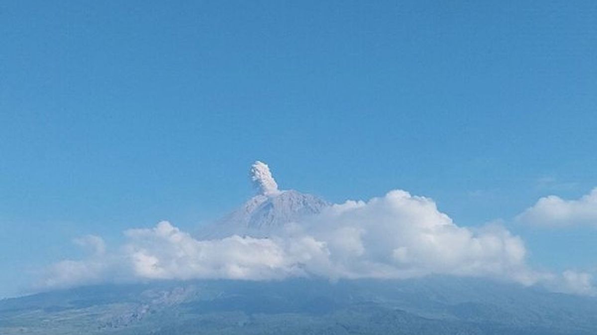
Mount Semeru, which is located on the border of Lumajang Regency with Malang, East Java, erupted with an eruption accompanied by volcanic ash as high as 900 meters above the peak, or about 4,576 meters above sea level (masl) on Saturday at 08.01 WIB.
"The ash column was observed to be white to gray with thick intensity to the southwest and west. The eruption was recorded on a seismograph with a maximum amplitude of 23 mm and a duration of 115 seconds," said Mount Semeru Observation Post Officer Sigit Rian Alfian, quoted from ANTARA, Saturday, June 29.
Based on the records of the Mount Semeru Observation Post officer, the mountain, which has a height of 3,676 meters above sea level, has erupted seven times on June 29, 2024, from 00.00 WIB to 09.00 WIB.
The first eruption occurred at 00.38 WIB, followed by the second eruption at 00.57 WIB, then at 05.23 WIB, 05.28 WIB, and 05.44 WIB.
The visual eruption of the five eruptions was not observed because it was covered in fog and when the eruption report was made, it was observed that the eruption was still ongoing.
Then another eruption of Mount Semeru occurred at 07.19 WIB with a column height of ash observed about 700 meters above the peak.
The ash column was observed to be white to gray with thick intensity to the southwest. The eruption was recorded on a seismograph with a maximum amplitude of 22 mm, and a duration of 121 seconds.
It didn't take long for the eruption to occur at 08.01 WIB with an ash column height of about 900 m above the peak.
The ash column was observed to be white to gray with thick intensity to the southwest and west. The eruption was recorded on a seismograph with a maximum amplitude of 23 mm and a duration of 115 seconds.
Previously, the Head of the Geological Agency of the Ministry of Energy and Mineral Resources (ESDM) Muhammad Wafid said that hot clouds and incandescent lava avalanches were still occurring on Mount Semeru, but visually rarely observed because they were constrained by the foggy weather.
"Based on the results of the analysis and evaluation, the level of activity of Mount Semeru remains at Level III or Alert with recommendations that are adjusted to the potential for the latest danger," he said.
Therefore, his party provides recommendations so that people do not carry out any activities in the southeast sector along Besuk Kobokan as far as 13 kilometers from the summit (the center of the eruption).
SEE ALSO:


Then outside of that distance, he said, the community was also advised not to carry out activities at a distance of 500 meters from the river bank (river border) along Besuk Kobokan, because it has the potential to be affected by the expansion of hot clouds and lava flows up to a distance of 17 km from the summit.
Then residents are also prohibited from doing activities within a radius of five kilometers from the crater/peak of Mount Semeru, because they are prone to the danger of throwing stones (pijar).
The English, Chinese, Japanese, Arabic, and French versions are automatically generated by the AI. So there may still be inaccuracies in translating, please always see Indonesian as our main language. (system supported by DigitalSiber.id)
Most Popular Tags
#Prabowo Subianto #donald trump #2026 World Cup #Febrie Adriansyah #8791Popular


