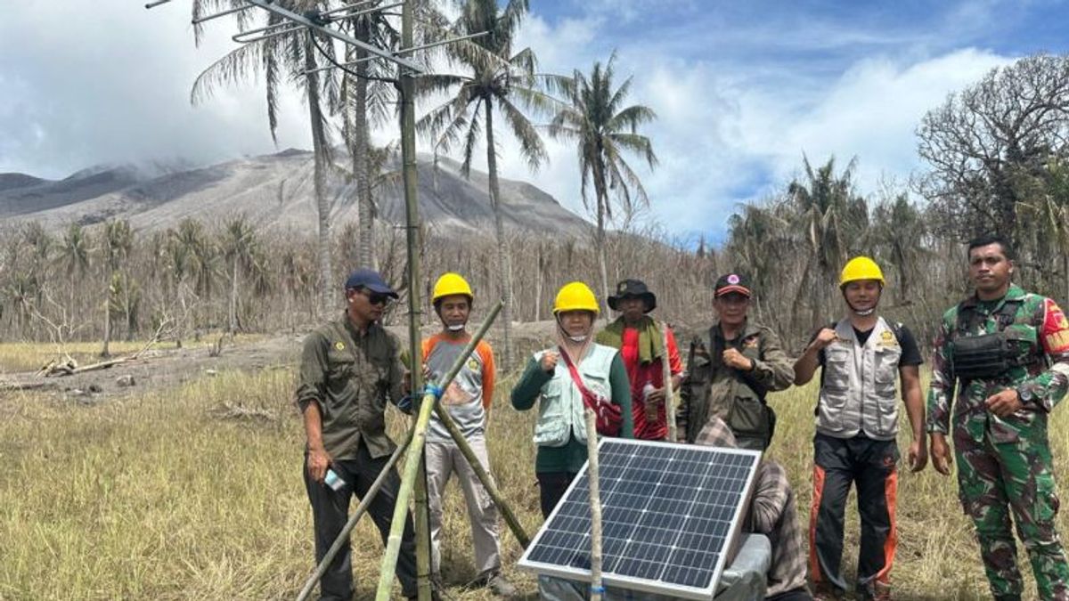


The Geological Agency of the Ministry of Energy and Mineral Resources (ESDM) has installed new seismic equipment to replace seismic installations that were damaged twice by the eruption of Mount Ruang in Sitaro Regency, North Sulawesi (Sulut).
Head of the Center Volcanology and Geological Hazard Mitigation Team (PVMBG) Heruningtyas said the seismic installation was installed on Ruang Island, which is about two kilometers from the crater peak of Mount Ruang.
"In principle, closer seismic monitoring to the source will be better," said Tyas as quoted by ANTARA, Friday, May 3.
The eruption activity that occurred on April 17 and April 30, 2024, damaged a seismic station 1.5 kilometers and 2.7 kilometers from the crater center.
The two eruptions caused the activity of recording volcanic activity and seismicity to be disrupted due to the distance from the Mount Ruang observation post on Tamulandang Island as far as five kilometers from the crater center.
When volcanic activity subsided on May 3, 2024, Tyas and the Geological Agency team moved closer to Mount Ruang to slowly install the new seismic so that they could accurately record various volcanic seismic activity as high as 725 meters above sea level (masl).
"We choose areas that are still green and are not exposed to hot clouds and materials, such as lahars," said Tyas.
The types of earthquakes that can be recorded are volcanic earthquakes that indicate magma migration from the inside to the surface, and surface earthquakes such as eruption earthquakes and low-frequency earthquakes.
Even the new seismic equipment can also record various earthquakes sourced from tectonic activity.
Tyas explained that the installation of seismic installations carried out today used bamboo and plastic to avoid corrosion.
SEE ALSO:


The Geological Agency team used makeshift tools because the materials shops selling iron that were resistant to corrosion were closed due to the eruption of Mount Ruang.
According to Tyas, the most important thing now is to record volcanic activity and seismicity accurately through the new seismic station, considering that currently the status of Mount Ruang is still Level IV or Alert.
When the status of the strato-type volcano drops, a seismic station will be made using concrete with a steel wire fence around the station.
"We are now only using makeshift equipment for temporary stations. If the mountain is back to normal, we will build a permanent installation using concrete," said Tyas.
The English, Chinese, Japanese, Arabic, and French versions are automatically generated by the AI. So there may still be inaccuracies in translating, please always see Indonesian as our main language. (system supported by DigitalSiber.id)
Most Popular Tags
#Prabowo Subianto #donald trump #2026 World Cup #Febrie Adriansyah #8791Popular


