JAKARTA - The Geological Agency of the Ministry of Energy and Mineral Resources revealed that quaternary and tertiary rock deposits that experienced weathering strengthened the effects of shocks and were prone to earthquakes in the southern waters of Banten Province.
"The southern part of Pandeglang, Lebak and Sukabumi Regencies is classified as prone to earthquakes and tsunamis, so mitigation efforts must be further improved through structural and non-structural mitigation," said Head of the Geological Agency Muhammad Wafid as reported by ANTARA, Monday, February 26.
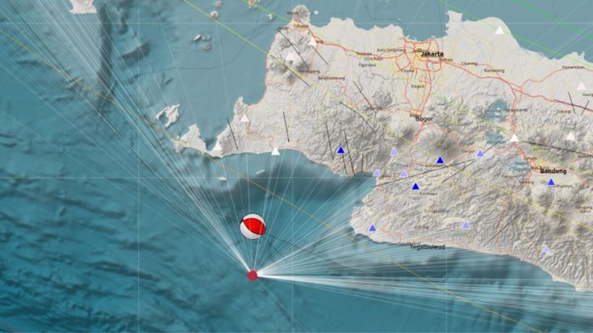
On February 25, 2024, two earthquakes were strong enough to shake the southern coast of Banten Province.
The first earthquake occurred at 20.07 WIB with a magnitude of 5.6 at a depth of 23 kilometers. Then, the second earthquake shook with a magnitude of 5.1 at 22.04 WIB.
The closest locations to the epicenter were the southern areas of Lebak and Pandeglang Regencies, Banten Province, and Sukabumi Regency, West Java.
The morphology of these areas is generally land, bumpy plains, and bumpy hills to steep. The coastal area is generally composed by moderate soil (class D) and soft soil (class E).
The area is generally composed by tertiary-aged rocks in the form of sediment rocks (sandstones, clays, lanau stones, limestone) and volcanic rock, as well as quartet deposits in the form of alumvial deposits on the coast, river alumvials, rock competitions for young volcanicoes and local swamp aluvials.
Some of the rocks with tertiary age and young volcanic rock have experienced weathering.
Based on the location of the earthquake center, depth and data on the source mechanism from the BMKG, the earthquake was caused by the activity of the sharpening zone with the fault mechanism rising relatively northwest to southeast.
SEE ALSO:
The Geological Agency revealed that the distribution of residential areas that were affected by earthquake shocks was mostly located in areas prone to high earthquakes. The earthquake did not cause a tsunami even though the location of the epicenter was located at sea, and it is estimated that it would not result in underwater deformation that could trigger a tsunami.
According to data from the Geological Agency, the southern coastal areas of Pandeglang, Lebak and Sukabumi Regencies are classified as tsunami-prone with a high potential tsunami on the coastline of more than three meters.
The Geological Agency said that buildings in the three areas must be built using earthquake-resistant buildings to avoid the risk of damage. Buildings must also be equipped with evacuation routes and places.
The English, Chinese, Japanese, Arabic, and French versions are automatically generated by the AI. So there may still be inaccuracies in translating, please always see Indonesian as our main language. (system supported by DigitalSiber.id)
