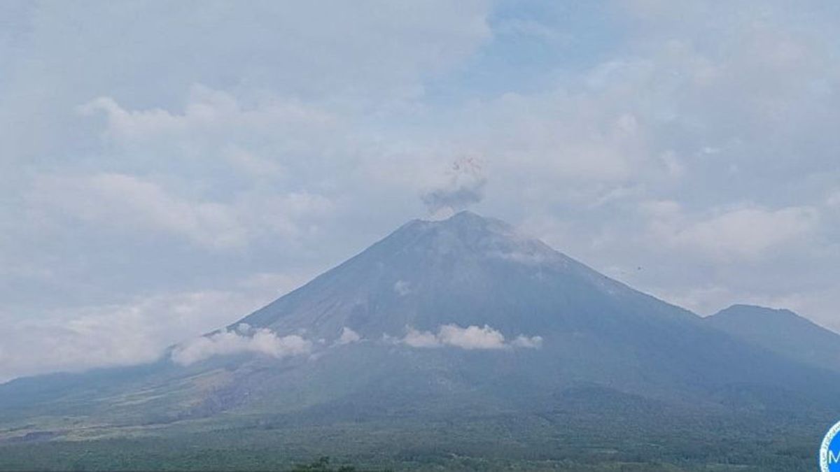


Mount Semeru, which is on the border of Lumajang and Malang Regencies, East Java, experienced two eruptions with an eruption as high as 800 meters above the peak on Wednesday at 05:57 WIB and 07:12 WIB.
Semeru Volcano Observation Post (PPGA) officer, Liswanto said that the eruption of Mount Semeru on Wednesday, at 05:57 WIB with an eruptive column height was observed to be about 800 meters above the peak.
"The volcanic ash column was observed to be white to gray with moderate intensity to the northeast. When the report was made, the eruption was still ongoing," he said in Lumajang in a written statement, Antara, Wednesday night.
Meanwhile, the second eruption of Mount Semeru occurred at 07:12 WIB with an eruption column height of about 800 meters above the peak (4,476 meters above sea level).
The volcanic ash column is observed to be gray to brown with moderate intensity to the north and northeast. The eruption was recorded on a seismograph with a maximum amplitude of 22 mm and a duration of 144 seconds.
The status of Mount Semeru at level III or alert, so that people are prohibited from carrying out any activities in the southeast sector along Besuk Kobokan, as far as 13 km from the summit (the center of the eruption).
Beyond this distance, the community does not carry out activities at a distance of 500 meters from the riverbank (river border) along Besuk Kobokan because it has the potential to be affected by the expansion of hot clouds and lava flows up to a distance of 17 km from the summit.
Then the community should not move within a 5 km radius of the crater/peak of Mount Semeru because it is prone to the danger of throwing stones (pijar).
The public is also advised to be aware of the potential for hot clouds, lava avalanches, and lahars along rivers/valleys that originate at the peak of the Semeru Volcano, especially along Besuk Kobokan, Besuk Bang, Besuk Kembar, and Besuk Sat as well as the potential for lahars in small rivers which are tributaries of Besuk Kobokan.
SEE ALSO:
-
 | BERITA
Kaesang Blusukan ke Kampung Pulo Banda Ciputat Promosikan UMKM Warga
02 Januari 2024, 22:16 -
 | BERITA
Hasto Klaim Blusukan Ganjar Disambut Antusias Warga Berbeda dengan Prabowo
02 Januari 2024, 19:42


The English, Chinese, Japanese, Arabic, and French versions are automatically generated by the AI. So there may still be inaccuracies in translating, please always see Indonesian as our main language. (system supported by DigitalSiber.id)
Add VOI as a Preferred Source
Follow VOI news updates across Google.
+
Most Popular Tags
#Prabowo Subianto #donald trump #2026 World Cup #Febrie Adriansyah #8791Popular


22 Juli 2026, 01:01


