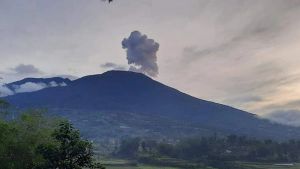
Mount Anak Krakatau erupted again on Tuesday at 18.00 WIB. The mountain in the waters of the Sunda Strait, the South Lampung region, ejected ash as high as 1,400 meters above the peak.
Based on information broadcast by the Center for Volcanology and Geological Hazard Mitigation (PVMBG), the eruption was recorded on a seismograph with a maximum amplitude of 70 mm and a duration of approximately 2 minutes 32 seconds.
During the eruption, Mount Anak Krakatau threw gray to black ash with moderate intensity to the northwest.
Mount Anak Krakatau was previously reported to have experienced an eruption at 04.38 WIB, at 12.56 WIB, and at 16.25 WIB. During the eruption, the volcano ejected ash to the northwest.
Head of the Mount Anak Krakatau Monitoring Post in Hargopancuran, South Lampung, Andi Suardi, said that Mount Anak Krakatau is at Level III or Alert.
SEE ALSO:
Andi appealed to residents and fishermen not to approach the area within a radius of five kilometers from the active crater of Mount Anak Krakatau.
He said that the residential area closest to Mount Anak Krakatau is on Sebesi Island, which is about 16.5 kilometers from the mountain.
Acting Head of the Regional Disaster Management Agency (BPBD) of South Lampung Regency, Aflah Efendi, has also appealed to residents living in coastal areas and Sebesi Island to increase preparedness to face the impact of the eruption of Mount Anak Krakatau.
According to him, until now there have been no reports regarding the impact of the eruption of Mount Anak Krakatau on residential areas in the surrounding area.
The English, Chinese, Japanese, Arabic, and French versions are automatically generated by the AI. So there may still be inaccuracies in translating, please always see Indonesian as our main language. (system supported by DigitalSiber.id)


