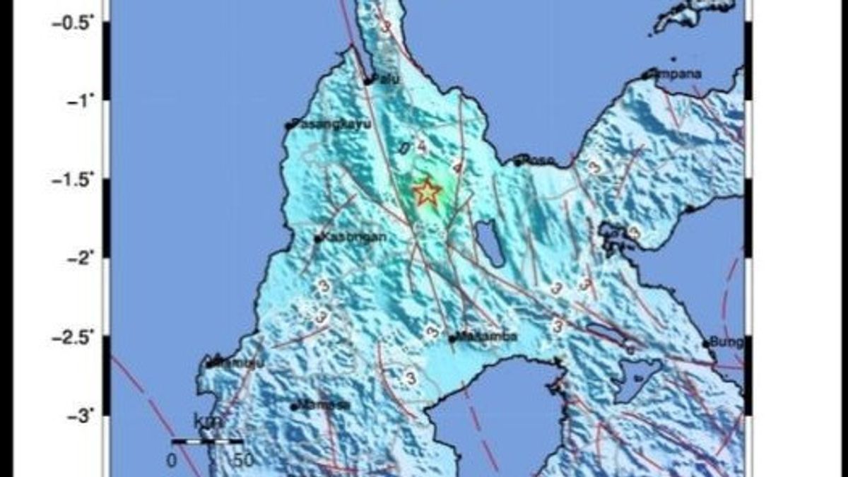


JAKARTA - An earthquake with a magnitude of 5.5 that occurred on Monday at 08.26 WIB in the Sigi Regency, Central Sulawesi Province, was caused by fault activity.
The epicentre of the tectonic earthquake was on land at coordinates 1.57 south latitude and 120.26 east longitudes or approximately 46 km southeast of Sigi at a depth of 10 km.
"Taking into account the location of the epicentre and the depth of the hypocenter, the earthquake that occurred was a type of shallow earthquake due to fault activity", said BMKG Earthquake and Tsunami Center Head Daryono, Monday 27 February.
The earthquake's vibrations were felt in the Sigi area on the Modified Mercally Intensity (MMI) IV intensity scale or could be felt by many people inside the house if it occurred during the day.
In addition, earthquakes were felt on an intensity scale of III to IV MMI in the areas of Palu, Poso, Wuasa, Toli-toli, Buol, North Morowali, Mamuju, Ampana, Wakai-Togean Islands, Pasangkayu, Malili, Majene and Masamba.
VOIR éGALEMENT:
-
 | EKONOMI
MinyaKita Hilang di Bengkulu, Minyak Goreng Premium Naik Rp 21 Ribu Per Liter
26 Februari 2023, 16:54 -
 | BERITA
Pelecehan Seksual di Transjakarta Terjadi Lagi, Korban Masih di Bawah Umur
26 Februari 2023, 16:20


On the MMI III scale, the earthquake vibrations were felt inside the house, felt as if a truck had passed.
In the Polewali Mandar and Central Mamuju areas, the vibrations caused by the earthquake were felt on the MMI II scale, felt by several people and caused light objects that were hanging to sway.
Daryono said that according to BMKG monitoring until 08.55 WIB there were four aftershocks with the largest magnitude of 4.5 after the earthquake with a magnitude of 5.5 which occurred on Monday at 08.26 WIB.
He appealed to residents in the earthquake-affected areas to avoid buildings that were cracked or damaged by the earthquake and to inspect residential buildings to ensure no damage could endanger the stability of the buildings before returning to their homes.
The English, Chinese, Japanese, Arabic, and French versions are automatically generated by the AI. So there may still be inaccuracies in translating, please always see Indonesian as our main language. (system supported by DigitalSiber.id)
Tags les plus populaires
#Prabowo Subianto #Golkar #OTT KPK #élections jakarta #jeux d’argent en lignePopulaire