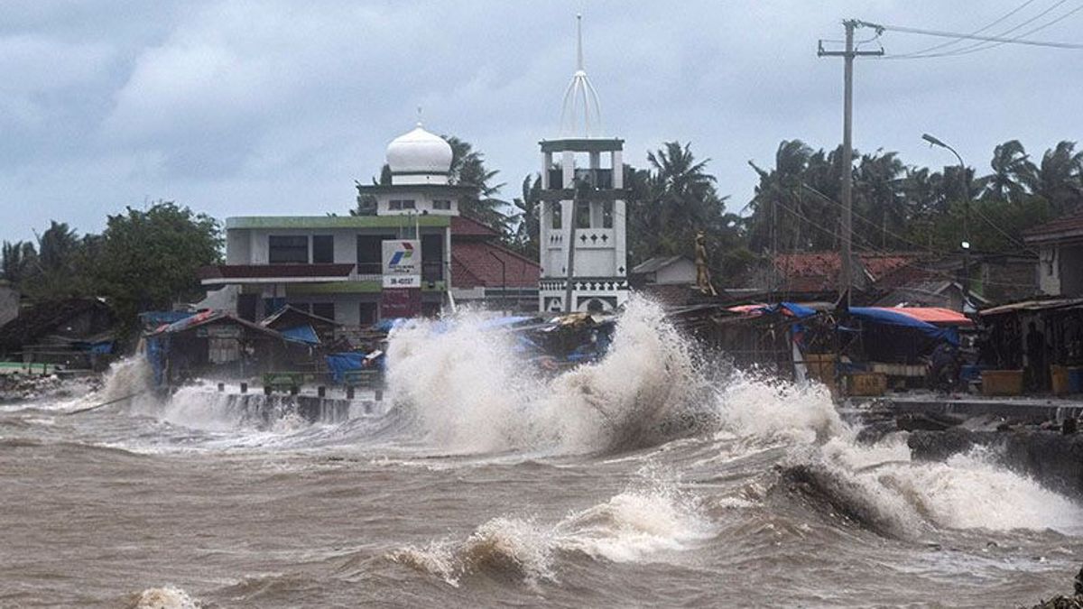


JAKARTA - The Meteorology, Climatology and Geophysics Agency (BMKG) has asked people who live and work on the coast to be aware of high waves that could potentially occur in several water areas in Indonesia on September 29-30.
"We ask that people who live and work on the coast around areas where high waves are likely to occur to stay alert," said Head of the BMKG Maritime Meteorology Center, Eko Prasetyo, as quoted by ANTARA, Wednesday, September 28.
He stated that the wind pattern in the northern part of Indonesia is dominantly moving from the east-southeast with wind speeds ranging from 5-25 knots.
In the southern part of Indonesia, the dominant movement is from east-southeast with wind speeds ranging from 5-20 knots.
The highest wind speeds were observed in the northern part of the Malacca Strait, the northern waters of Sabang, the southern part of the Sunda Strait, the Sulawesi Sea, and the Arafuru Sea.
This condition causes high waves in the range of 1.25-2.5 meters to occur in the eastern waters of Simeulue Island, southern Lampung Bay, southern Sape Strait, western Sumba Strait, Sawu Sea, Ombai Strait, and Sawu Island waters. Rotte-Kupang, northern Natuna Sea, northern Lombok Strait, North Kalimantan waters.
VOIR éGALEMENT:
-
 | BERITA
Puan Maharani Menimbang-nimbang Pilpres 2024: Insyaallah Akan Ada Teman untuk Menuju 2024
28 September 2022, 15:57


Similar conditions also have the potential to occur in the Sulawesi Sea, the waters of the Sangihe Islands-Talaud Islands, the waters of the Bitung-Sitaro Islands, the northern part of the Maluku Sea, the northern waters of Sorong to Jayapura, the northern Pacific Ocean from Halmahera to Papua, the southern waters of the Sermata Islands to the Tanimbar Islands, the southern waters Aru Islands, and Arafuru Sea.
For waves in the higher range of 2.5-4 meters, there is a chance to occur in the northern part of the Malacca Strait, northern waters of Sabang, western waters of Aceh to the Mentawai Islands, waters of Enggano-Bengkulu Island, western waters of Lampung.
In addition, the Indian Ocean west of Sumatra, the western and southern parts of the Sunda Strait, the southern waters of the island of Java to Sumba Island, the Bali Strait, Lombok, southern Alas, the Indian Ocean south of Java to NTT.
Eko Prasetyo asked residents to pay attention to high risks to shipping safety such as fishing boats (wind speed more than 15 knots and wave height above 1.25 m), barges (wind speed more than 16 knots and wave height above 1.5 m).
Ferries (wind speed more than 21 knots and wave height above 2.5 m), large size vessels such as cargo/cruise ships (wind speed over 27 knots and wave height above 4.0 m).
The English, Chinese, Japanese, Arabic, and French versions are automatically generated by the AI. So there may still be inaccuracies in translating, please always see Indonesian as our main language. (system supported by DigitalSiber.id)
Tags les plus populaires
#Prabowo Subianto #Nouvel An #Syrie #nataru #NatalPopulaire