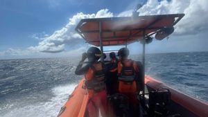


BANTEN - The Center for Volcanology and Geological Hazard Mitigation (PVMBG) asked fishermen, tourists, climbers, and the public not to move within a radius of 5 kilometers from the eruption center in the crater of the summit of Mount Anak Krakatau, which is in the Sunda Strait waters between Banten and Lampung Provinces.
Based on the KSDM page of the Geological Agency PVMBG, the Pasauran Observation Post for the Krakatau Volcano, Fahrul Rozi said, at around 12.00 to 18.00 western Indonesia time, the height of Mount Anak Krakatau was 157 meters above sea level (masl), the weather was sunny, cloudy 26-28.3 degrees Celsius and 41-50 percent.
"Currently, the status of Mount Anak Krakatau is on standby or level 3, so it is recommended that the public, mountaineers, fishermen, and tourists should not approach the eruption center with a radius of 5 kilometers," he explained, quoted from Antara, Sunday, July 31.
Visually, the area of Mount Anak Krakatau is covered with 0-III fog and crater smoke is not observed. The earthquake with the frequency of Mount Anak Krakatau occurred once, with an amplitude of 6 mm and a duration of 4 seconds.
Meanwhile, the shallow volcanic earthquakes of Mount Anak Krakatau occurred twice, with an amplitude of 7-14 mm and a duration of 7-12 seconds. Meanwhile, the microtremor/tremor is continuous with an amplitude of 0.5-7 mm and a dominant amp of 0.5 mm.
VOIR éGALEMENT:


Thus, until now the status of Mount Anak Krakatau is recommended to be 5 km and it is dangerous for fishermen, communities, mountain climbers and tourists if they approach the crater of the volcanic eruption.
The English, Chinese, Japanese, Arabic, and French versions are automatically generated by the AI. So there may still be inaccuracies in translating, please always see Indonesian as our main language. (system supported by DigitalSiber.id)