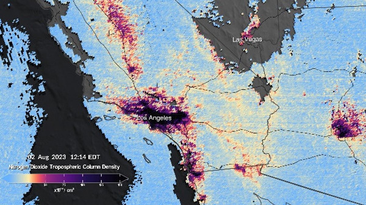


JAKARTA - NASA's Troposphere Emissions Instrument: Pollution Monitoring (TEMPO) has just shared its first image, showing how the satellite can track air pollution.
Launched earlier this year, TEMPO orbited 22.000 miles above the equator. The first space-based instrument was designed to continue to measure air quality over North America with a resolution of several square miles.
The first pollution map released by NASA from the mission shows the concentration of nitrogen dioxide gas from pollution around major cities and transportation routes in North America.
TEMPO measures sunlight that is reflected and dissipated on the surfaces of the earth, clouds, and the atmosphere. Gas in the atmosphere absorbs sunlight, and the resulting spectrum is then used to determine the concentration of several gases in the air, including nitrogen dioxide.
The visualization shows six scans carried out between 11:12 p.m. to 17:27 a.m. EDT on August 2. Close-up views focus on the US southwest region from Los Angeles to Las Vegas.
Then, from central and eastern Texas to New Orleans and Interstate 95 corridor between New York and Washington.
The data was collected during the TEMPO's first light period, from July 31 to August 2, when the mission controller opened the spectrometer to see the Sun and Earth and started various solar tests and calibrations.
SEE ALSO:
-
 | TEKNOLOGI
Spanyol Bentuk Badan Pengawas Kecerdasan Buatan, Pertama di Eropa
28 Agustus 2023, 09:05 -
 | TEKNOLOGI
6 Cara Mengatasi Virtex WA untuk Mengembalikan WhatsApp Normal Lagi
28 Agustus 2023, 07:31


The TEMPO begins to measure air pollution every hour in the North American region. It measures ozone, nitrogen dioxide, formaldehyde, aerosol, water vapor, and several gas tracks. There have been nearly 50 science studies planned based on new ways to collect data," said senior physicistatural Astrophysical Observatory (SAO) and TEMPO lead researcher Kelly Chance in a statement, quoted Monday, August 28.
For further missions, TEMPO will scan every hour during the day against North America's lower atmosphere from the Atlantic Ocean to the Pacific coast and from around Mexico City to central Canada, which began full operations in October.
The main instrument is a state-of-the-art spectrometer that detects pollution that is usually hidden in the reflection of sunlight.
TEMPO observations will greatly improve studies on pollution caused by traffic during peak hours, the movement of smoke and ash from forest and volcanic fires, as well as the impact of the use of fertilizers on agricultural land.
In addition, TEMPO data will help scientists evaluate the impact of pollutants on health and help create air pollution maps on an environmental scale, thereby increasing understanding of the air quality gap in a community.
The English, Chinese, Japanese, Arabic, and French versions are automatically generated by the AI. So there may still be inaccuracies in translating, please always see Indonesian as our main language. (system supported by DigitalSiber.id)
Most Popular Tags
#Prabowo Subianto #donald trump #2026 World Cup #venezuela #Bhayangkara hut #konflik timur tengahPopular


