

JAKARTA - The Meteorology, Climatology and Geophysics Agency (BMKG) recorded 19 aftershocks that rocked Berau, East Kalimantan, from Sunday (15/9) early morning until Monday morning.
"The series of aftershocks have a magnitude of 4.2 - the smallest 2.8 magnitudes - until 09.00 WIB," said Head of the BMKG Earthquake and Tsunami Center Daryono in Jakarta, Monday, September 16.
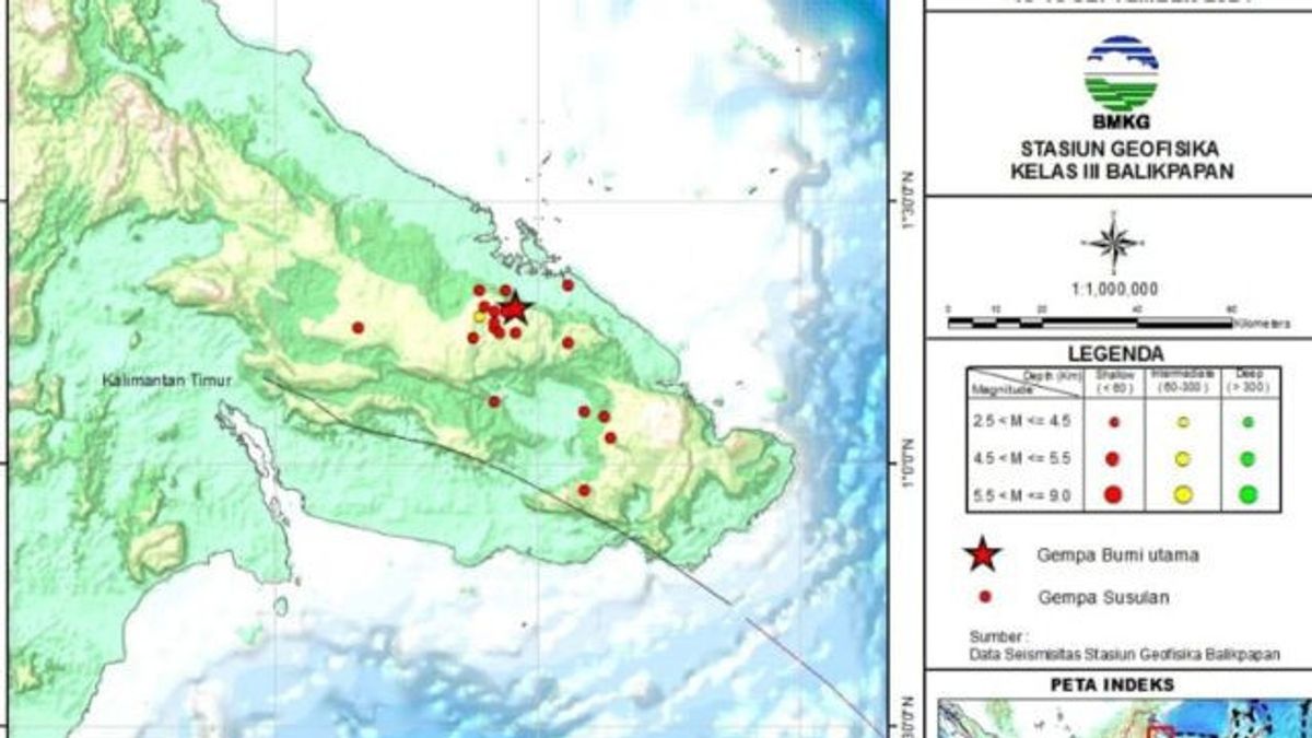
According to him, based on the analysis of the BMKG team, the series of earthquakes spread over several points located on land in East Kalimantan. The epicenter of the largest earthquake was on land in the Batu Putih area, Biduk-Biduk, Berau, which was detected with a magnitude of 5.6 on Sunday at 21.08 WITA.
The BMKG detected the earthquake occurred due to the activity of the Manggalihat fault in Berau, which was not related to the megathrust zone and did not have the potential to cause a tsunami.
However, Daryono ensured that development conditions will always be monitored and its development will soon be informed to the public using all BMKG information resources.
"Hopefully the tectonic condition can be stable and safe again soon," he said.
His party assessed that the earthquake incident should be a sign so that the people of East Kalimantan remain vigilant and always follow directions from the government. This is because based on historical records, East Kalimantan has been rocked by a large earthquake to reach the VII MMI maximum intensity scale on May 14, 1921.
SEE ALSO:
-
 | BERITA
Tersangka Pembunuhan Pegawai Indomaret Sudah Bekerja Selama 4 tahun, Kenal Korban Baru 3 Bulan
11 September 2024, 19:28 -
 | BERITA
Pegawai Indomaret Tusuk Teman Kerjanya karena Diminta Penuhi Hasrat Seksual
11 September 2024, 19:16 -
 | BERITA
Warga Perum Bojonggede Asri Ditemukan Tewas dengan Leher Terikat di Kebun Teh
10 September 2024, 16:23

The earthquake caused damage to the Sangkulirang area with the most severe damage to occur on Rending Island or Sangkulilang Bay. Many houses were damaged in Kaliorang and Sekurau.
In addition, the impact of the earthquake also caused the borehole to spray water, there were 10 meters of soil fractures, 20 centimeters wide with a depth of 2 meters, and water mixed with sand and clay or liquefaction.
The area that was rocked by this earthquake reached a radius of 250 kilometers followed by 10 repeated strong shocks. The earthquake triggered by the Sangkulilang Fault Zone (Sangkulang Fault Zone) triggered a tsunami that caused severe damage in Serurau.
Daryono said that based on the testimony of eyewitnesses in various sources of literacy, the earthquake noted that at that time the tsunami inundated a road up to 1 meter high.
The English, Chinese, Japanese, Arabic, and French versions are automatically generated by the AI. So there may still be inaccuracies in translating, please always see Indonesian as our main language. (system supported by DigitalSiber.id)


