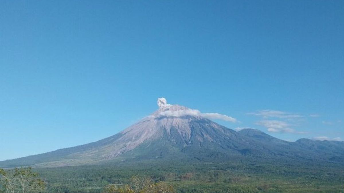


LUMAJANG - Mount Semeru, which has a height of 3,676 meters above sea level (masl) in Lumajang and Malang regencies, East Java (East Java), was recorded twice as an eruption on Saturday morning.
The first eruption occurred at 05.38 WIB with an eruptive column height of about 500 meters above the peak or about 4,176 mdpl.
"The ash column was observed to be gray with thick intensity to the west. The eruption was recorded on a seismograph with a maximum amplitude of 22 mm and a duration of 128 seconds," said Mount Semeru Observation Post Officer Yadi Yuliandi as reported by ANTARA, Saturday, September 14.
The second eruption occurred at 06.37 WIB and the height of the eruption column was observed at around 700 meters above the peak or 4,376 meters above the peak.
The ash column was observed to be white to gray with thick intensity to the west. The eruption was recorded on a seismograph with a maximum amplitude of 22 mm and a duration of 108 seconds.
Mount Semeru is still on Alert status, so the Center for Volcanology and Geological Hazard Mitigation (PVMBG) provides a number of recommendations, namely that people are prohibited from carrying out any activities in the southeast sector along Besuk Kobokan, as far as eight kilometers from the summit (the center of the eruption).
SEE ALSO:
-
 | BERITA
Pramono Sebut Jalur Sepeda di Era Anies Setengah Hati: Bagus Tapi Belum Tuntas
14 September 2024, 10:16 -
 | BERITA
Finlandia-Swedia Tak Batasi Ukraina Gunakan Senjata Pasokannya Serang Rusia
14 September 2024, 09:26 -
 | BERITA
Paus Fransiskus Kritik Kamala Harris dan Donald Trump soal Deportasi Imigran dan Aborsi
14 September 2024, 08:45

Then outside of that distance, people are not allowed to carry out activities at a distance of 500 meters from the riverbank (river border) along Besuk Kobokan, because it has the potential to be affected by the expansion of hot clouds and lava flows up to a distance of 13 km from the summit.
The community is also not allowed to move within a three km radius of the crater/peak of Mount Semeru, because it is prone to the danger of throwing stones (lightning).
In addition, it is necessary to be aware of the potential for hot clouds, lava avalanches, and lahars along rivers/valleys that originate at the peak of Mount Semeru, especially along Besuk Kobokan, Besuk Bang, Besuk Kembar, and Besuk Sat, as well as the potential for lahars in small rivers that are tributaries of Besuk Kobokan.
The English, Chinese, Japanese, Arabic, and French versions are automatically generated by the AI. So there may still be inaccuracies in translating, please always see Indonesian as our main language. (system supported by DigitalSiber.id)
Most Popular Tags
#Prabowo Subianto #donald trump #2026 World Cup #Febrie Adriansyah #8791Popular


