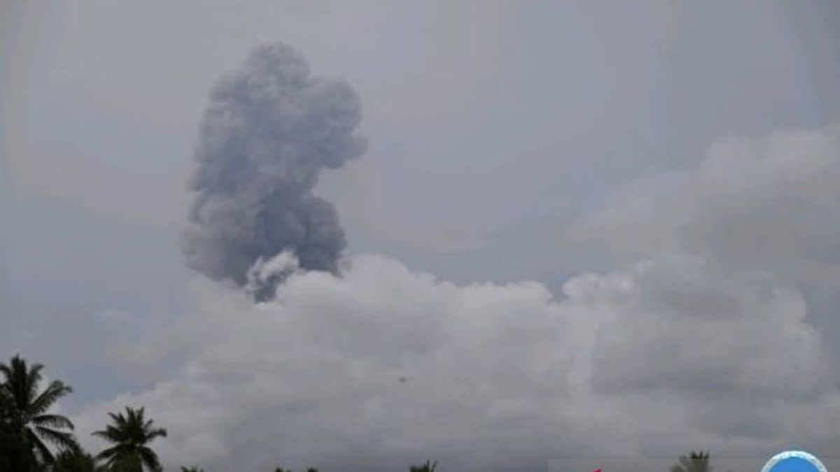


JAKARTA - The Geological Agency has set a radius of 4 kilometers (km) from the crater of Mount Ibu on Halmahera Island, North Maluku as a danger zone for people who are active after the volcano erupts six times with a maximum amplitude of 28 millimeters, this morning.
"People and tourists are asked not to carry out any activities at a radius of 4 kilometers and the sectoral expansion is 5 km to the crater opening in the north of the active crater of Mount Ibu," said Head of the Geological Agency M. Wafid in a statement in Jakarta, Antara, Friday, August 2.
He explained that the eruption of Mount Ibu at 09.41 WIT was recorded on the seismograph having a maximum amplitude of 28 millimeters or relatively large from general and lasted for approximately 2 minutes 11 seconds.
In the eruption, Mount Ibu blasts ash approximately 1.5 km into the air from an active crater or 2,825 meters above sea level with a column of gray to black ash with moderate to thick intensity to the north.
Two more eruptions occurred just one to three hours apart from before, this time recorded with a maximum amplitude of 9-24mm which lasted 2 minutes 13 seconds, the height of the ash column was observed as high as 1.5 km.
Three series of eruptions were then observed starting from 12.30 WIT to 15:38 WIT with an amplitude of 8-13 mm with a time of no more than 100 seconds.
Geological Agency officers on duty at the Tokuoko Village monitoring post reported that until now the volcanic activity of Mount Ibu is still at level III or on standby.
Therefore, in addition to reminding the danger zone of the community around Mount Ibu, it is hoped that they will always wear masks or nose coverings to avoid the dangers of respiratory system disturbances in the event of ash rain.
Mount Ibu is a volcano that has a peak height of 1,340 meters above sea level. Administratively, the mountain entered the area of Ibu District, West Halmahera Regency, North Maluku Province.
Sangaji Nyeku, Goin, Tokuoko, Duono, Tuguis, and Togoreba Sungi villages in West Halmahera Regency are a number of nearby residential areas from the direction of the crater opening of Mount Ibu.
On the other hand, based on the results of a field survey by the Geological Agency, the Center for Volcanology and Geological Hazard Mitigation (PVMBG) together with the National Disaster Management Agency (BNPB) of these villages, including the Cold Lahar Flood Disaster Prone Area (KRB). This is because the location of the village is a shear with a river flow from upstream of Mount Ibu which must also be watched out for.
From the results of geological analysis, it was recorded that there were as many as 300 thousand to 500 thousand cubic meters of material that had the potential to overflow from the crater opening along the river to the plantation area which had morphologies such as river valleys and hit existing locations.
SEE ALSO:
-
 | BERITA
Densus 88 Turut Periksa Orangtua Teroris yang Ditangkap di Batu Malang
01 Agustus 2024, 12:50


The English, Chinese, Japanese, Arabic, and French versions are automatically generated by the AI. So there may still be inaccuracies in translating, please always see Indonesian as our main language. (system supported by DigitalSiber.id)
Add VOI as a Preferred Source
Follow VOI news updates across Google.
+
Most Popular Tags
#Prabowo Subianto #donald trump #2026 World Cup #bgn #konflik timur tengahPopular


21 Juni 2026, 03:03


