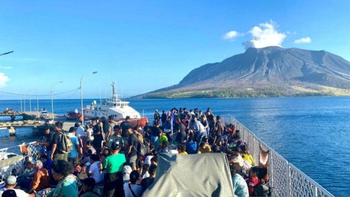


JAKARTA - The head of the National Disaster Management Agency (BNPB) revealed that the air around Mount Ruang, Tamulandang, Sitaro Islands Regency, North Sulawesi, still contained sulfur dioxide (SO2) gas that was ejected when the volcano erupted a few days ago.
"Every time there is a volcanic eruption, there is sulfur dioxide gas. This gas is not only disturbing the community, but also has an impact on flight activities, such as Mount Ruang," said Head of the BNPB Disaster Data and Information Center Abdul Muhari in Jakarta as reported by ANTARA, Monday, April 22.
According to him, the sulfur dioxide gas was scattered into the air along with the eruption of Mount Ruang, which until now according to the BNPB team is still emitting smoke from its peak.
Due to this condition, BNPB urges the public to always wear masks during activities so as to avoid respiratory problems or infections due to breathing the air containing SO2 or sulfur dioxide gas. BNPB also announced a safe zone limit for Tamulandang residents to carry out their activities, namely at a radius of four kilometers from the peak that still emits smoke.
The zone limit was obtained by BNPB based on the decision to reduce the status of Mount Ruang by the Center for Volcanology and Geological Hazard Mitigation (PVMBG) team, which was previously level IV (Awas) to level III or (Alert) on Monday morning at 09.00 WIB.
SEE ALSO:
-
 | BERITA
Ganjar: Saya dan Pak Mahfud Tinggal Hari Ini Saja, Akhir dari Perjalanan
22 April 2024, 17:11

Or if you have experienced symptoms of respiratory tract problems such as shortness of breath and so on, he said, the public will immediately report to the disaster emergency team for medical treatment.
"We have prepared a team of doctors from the TNI and Polri to carry out medical treatment. BNPB also provides masks that the community should have been able to use at this time," he said. sulfur dioxide gas content in the air in Tagulandang, Sitaro Islands, due to the eruption of Mount Ruangan was confirmed by Earth Investigator PVMBG Sofyan Primulyana.
Sofyan said that since April 17, 2024 at 13.15 WITA, satellite image data shows a value of 3,000 tons of sulfur dioxide from a column of smoke that extends more than 450 kilometers.
A day later at 14.30 WITA the value of sulfur dioxide was 300 thousand tons from the column of smoke which extends more than 1,000 kilometers. The contamination of sulfur dioxide occurred due to decreased volcanic activity and heavy rain. However, PVMBG analysis on April 19, 2024, found that the value of sulfur dioxide around Mount Ruang was detected to have decreased to around 190 thousand tons.
"Until April 22, 2024, through satellite imagery monitoring, we have not received any updates regarding the concentration of sulfur dioxide gas distribution on Mount Ruang," said Sofyan.
The English, Chinese, Japanese, Arabic, and French versions are automatically generated by the AI. So there may still be inaccuracies in translating, please always see Indonesian as our main language. (system supported by DigitalSiber.id)
Most Popular Tags
#Prabowo Subianto #donald trump #2026 World Cup #Febrie Adriansyah #8791Popular


