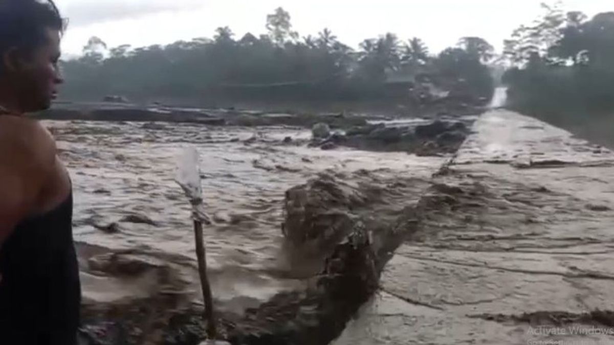


The tremors of the cold lava flood of Mount Semeru in Lumajang Regency, East Java, were recorded for more than 3 hours due to heavy rains in the highest mountain peak area on the island of Java.
Mount Semeru Observation Post officer Mukdas Sofian in a written report, as quoted from Antara, Sunday, March 3, stated that observations of the seismic activity of Mount Semeru on March 3, 2024 at 12.00-18.00 WIB showed a flood earthquake.
"Indeed, there was one earthquake with a flood earthquake with an amplitude of 35 mm, and an earthquake of 10,819 seconds or more than 3 hours," said Mukdas Sofian.
In addition to flood vibrations, the activity of Mount Semeru also experienced 10 eruption/eruption earthquakes with an amplitude of 11-22 mm, and a long earthquake of 50-125 seconds, then 2 harmonic times with an amplitude of 2-6 mm and a long earthquake of 75-120 seconds.
"For visual observations, Mount Semeru is clearly visible until it is covered in fog 0-III. The crater smoke is not observed. The weather is cloudy to rainy, the wind is weak to the north," he said.
In the CCTV footage monitored by the Lumajang BPBD, secondary eruptions were observed in the Besuk Kobokan and Lanang rivers, so that people were advised to be aware of the flow of hot lava.
The highest mountain on the island of Java erupted on Sunday at 00.13 WIB with visual eruptions not being observed, but the eruption was recorded on a seismograph with a maximum amplitude of 22 mm and a duration of 134 seconds.
SEE ALSO:
-
 | BERITA
16 Tahanan Polsek Kabur, IPW: Belum Tentu Petugas Lalai, Mereka Fokus Pengamanan Pemilu
19 Februari 2024, 21:01 -
 | BERITA
Warga Kodam Jaya Kemayoran Heboh, Sopir Bajaj dan Jukir Kejar-kejaran di Dalam Alfamart
18 Februari 2024, 08:52 -
 | BERITA
Polda Jateng Imbau Masyarakat Waspadai Konten Hoaks Pascapencoblosan Pemilu 2024
18 Februari 2024, 09:15 -
 | BERITA
Dua Rumah Warga Duren Sawit Diteror, Meteran Listrik Dibakar Orang Tak Dikenal
16 Februari 2024, 18:18 -
 | BERITA
Suara Prabowo-Gibran di TPS 34 Ciputat Melonjak Drastis, Bawaslu Sadar Ada yang Salah
15 Februari 2024, 10:22


Then the eruption of Mount Semeru occurred again at 19.10 WIB with visually unobserved eruptions, the eruption was recorded on a seismograph with a maximum amplitude of 22 mm and a duration of 114 seconds.
The status of the mountain, which has a height of 3,676 meters above sea level, is still on standby or level III, so people are prohibited from carrying out any activity in the southeast sector along Besuk Kobokan, as far as 13 km from the summit (the center of the eruption).
Beyond this distance, the public is asked not to carry out activities at a distance of 500 meters from the riverbank (river border) along Besuk Kobokan because it has the potential to be affected by the expansion of hot clouds and lava flows up to a distance of 17 km from the summit.
Then the community should not move within a 5 km radius of the crater/peak of Mount Semeru because it is prone to the danger of throwing stones (pijar).
The public is also advised to be aware of the potential for hot clouds, lava avalanches, and lahars along rivers/valleys that originate at the top of Mount Semeru, especially along Besuk Kobokan, Besuk Bang, Besuk Kembar, and Besuk Sat as well as the potential for lahars in small rivers which are tributaries of Besuk Kobokan.
The English, Chinese, Japanese, Arabic, and French versions are automatically generated by the AI. So there may still be inaccuracies in translating, please always see Indonesian as our main language. (system supported by DigitalSiber.id)
Most Popular Tags
#Prabowo Subianto #donald trump #2026 World Cup #Febrie Adriansyah #8791Popular


