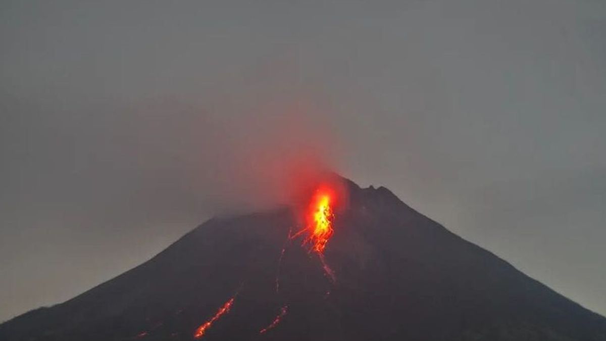


JAKARTA - Head of the Geological Disaster Technology Research and Development Center (BPPTKG) Agus Budi Santoso said Mount Merapi launched 143 lava avalanches to the south and southwest during the week from January 26 to February 1, 2024.
The mountain, which is located on the border of Central Java and Yogyakarta, launched incandescent lava three times sliding to Kali Boyong for a maximum of 1 kilometer and 140 times leading upstream of Bebeng River as far as a maximum of 1,700 meters.
"The sound of avalanches was heard three times from the Babadan Post with a small intensity," Agus said as quoted by ANTARA, Saturday, February 3.
BPPTKG noted that this week's lava avalanches increased three times from the previous week in the period 19-25 January 2024. At that time, lava avalanches were recorded to have appeared 47 times to the upper reaches of Bebeng River as far as 1.5 kilometers.
In addition to lava avalanches, BPPTKG also noted that there were 10 hot clouds of avalanches leading to the southwest (Hulu Kali Bebeng) with a maximum sliding distance of 2,400 meters. The number of hot clouds this week tends to decrease when compared to the hot clouds last week which were recorded 19 times.
Agus said the morphology of the southwest dome had changed due to the activity of lava avalanches and hot clouds of avalanches. Meanwhile, the morphology of the middle dome is relatively fixed.
"The volcanic activity of Mount Merapi is still quite high in the form of effusive eruption activity," he said.
Throughout January 26 to February 1, 2024, Mount Merapi experienced a fairly high seismic intensity of 10 avalanche hot cloud earthquakes, 4 shallow volcanic earthquakes, 108 multi-phase earthquakes, 871 avalanches, and 1 tectonic earthquake.
SEE ALSO:
-
 | BERITA
Kim Jong Un Tekankan Pentingnya Perkuat Angkatan Laut untuk Persiapan Perang
03 Februari 2024, 05:32 -
 | BERITA
Turki Tangkap Tujuh Orang yang Dicurigai Jual Informasi ke Badan Intelijen Israel
03 Februari 2024, 04:00 -
 | BERITA
Anies Baswedan Jabarkan Konsep Indonesia Adil Makmur untuk Semua di Forum DPD RI
03 Februari 2024, 02:55 -
 | BERITA
Airlangga: Penyaluran Bansos Bentuk Kehadiran Pemerintah, Bukan Agenda Politik
02 Februari 2024, 23:58

The potential danger of Mount Merapi is currently in the form of lava avalanches and hot clouds in the south sector, including the Boyong River for a maximum of five kilometers, the Bedog River, Krasak, Bebeng for a maximum of seven kilometers.
In the southeast sector, including the Woro River is a maximum of three kilometers and the Gendol River is five kilometers. Meanwhile, the ejection of volcanic material in the event of an explosive eruption can reach a radius of three kilometers from the summit.
" Monitoring data shows that the supply of magma is still ongoing which can trigger hot clouds in potential hazard areas," concluded Head of BPPTKG Agus Budi Santoso.
The English, Chinese, Japanese, Arabic, and French versions are automatically generated by the AI. So there may still be inaccuracies in translating, please always see Indonesian as our main language. (system supported by DigitalSiber.id)
Most Popular Tags
#Prabowo Subianto #donald trump #2026 World Cup #Febrie Adriansyah #8791Popular


