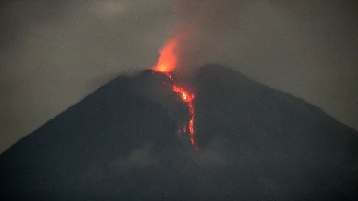


JATIM - Head of Emergency and Logistics Division of the Lumajang Regency BPBD Yudi Cahyono said Mount Semeru had erupted every day for the last few days.
Yudi said the information was obtained based on data from the Semeru Volcano Observation Post on Mount Sawur.
"It is true that almost every day there is an eruption, but the scale is small and has no impact on residents who are on the slopes of Mount Semeru," he said when contacted in Lumajang, East Java, Thursday, January 25, as reported by Antara.
Based on information on volcanic eruptions on the website of the Ministry of Energy and Mineral Resources, Mount Semeru has experienced an eruption every day since Monday, January 22 at 15.40 WIB.
However, visual eruptions were not observed and the eruption was recorded on a seismograph with a maximum amplitude of 22 mm and a duration of 101 seconds.
On Tuesday, January 23, there was two eruptions at 15.48 WIB with visually unobserved eruptions and the eruption was recorded on a seismograph with a maximum amplitude of 22 mm and a duration of 128 seconds.
The second eruption occurred at 18.53 WIB with a height of volcanic ash observed about 800 meters above the peak and the eruption was recorded on a seismograph with a maximum amplitude of 22 mm and a duration of 123 seconds.
On Wednesday, January 24, there was a three-time eruption, namely at 07.25 WIB with a volcanic ash height observed about 700 meters above the peak, the second eruption occurred at 08.55 WIB and the third eruption occurred at 19.14 WIB with a ash column height observed at 700 meters above the Jonggring Saloko peak.
Then on Thursday there was two eruptions at 05.06 WIB with a volcanic ash height observed about 900 meters above the peak and at 16.14 WIB with a column height of volcanic ash observed about 800 meters above the peak.
"We have carried out monitoring and the results have had no impact due to the eruption that has occurred during the last few days," he said.
SEE ALSO:
-
 | BERITA
Alasan Siskaeee Ajukan Penangguhan Penahanan: Gangguan Jiwa, Banyak Bekas Sayatan
25 Januari 2024, 13:25 -
 | BERITA
Jokowi Sebut Presiden Boleh Memihak, Anies Minta Ahli Hukum Tata Negara Mengkaji
25 Januari 2024, 13:41
The number of eruptions of Mount Semeru, which was recorded from January 1 to January 25 at 19.00 WIB, was 14 times in line with the status of the highest mountain on the island of Java being on standby or level III.
He appealed to the public not to carry out any activities in the southeast sector along Besuk Kobokan, as far as 13 km from the peak or the center of the eruption.
Beyond that distance, people are not allowed to carry out activities at a distance of 500 meters from the riverbank (river border) along Besuk Kobokan because it has the potential to be affected by the expansion of hot clouds and lava flows up to a distance of 17 km from the summit.
"Residents are also not allowed to move within a 5 km radius of the crater/peak of Mount Semeru because it is prone to the danger of throwing stones," he said.
The public is also asked to be aware of the potential for hot clouds, lava avalanches, and lahars along rivers/valleys that originate at the peak of the Semeru Volcano, especially along Besuk Kobokan, Besuk Bang, Besuk Kembar, and Besuk Sat as well as the potential for lahars in small rivers which are tributaries of Besuk Kobokan.
The English, Chinese, Japanese, Arabic, and French versions are automatically generated by the AI. So there may still be inaccuracies in translating, please always see Indonesian as our main language. (system supported by DigitalSiber.id)
Most Popular Tags
#Prabowo Subianto #donald trump #2026 World Cup #Febrie Adriansyah #8791Popular


