

JAKARTA - This afternoon, the central region of Indonesia was rocked by an earthquake that has the potential to cause a tsunami. Luckily the Meteorology, Climatology and Geophysics Agency (BMKG) has revoked the tsunami early warning in East Nusa Tenggara (NTT). However, we are advised to remain vigilant about earthquakes and other natural disasters. How ready is the country's disaster mitigation system?
An earthquake with a magnitude of 7.4 occurred in the Flores Sea at 10.20 am this morning. The epicenter of the earthquake was at a distance of 112 km northwest of Larantuka City, East Nusa Tenggara, at a depth of 10 KM.
One of the areas most affected by the earthquake was the Selayar Islands Regency, South Sulawesi. Several amateur videos recorded how the earthquake damaged buildings such as mosques and houses.
Meanwhile, the panic of residents on Karumpa Island, Selayar Regency was recorded when they ran to the mountains to look for higher places. This earthquake was also felt by residents in Buton Regency, Southeast Sulawesi.
After the earthquake, residents of Banabungi Village, Pasar Wajo Sub-district who live on the coast claimed to have seen the sea water rising fast. The news of rising sea levels made residents panic and leave their homes to go to the hills.

Panicked residents waited on the hill to monitor the sea level. Due to circulating information the sea water rose as high as half a meter. However, the Pasar Wajo Police Chief, as quoted by Kompas TV, said the sea water had risen by about 20 centimeters and returned to normal.
At 12.30 BMKG revoked the tsunami early warning for five provinces namely NTB, NTT, Maluku, South Sulawesi and Southeast Sulawesi. However, the BMKG appealed to the public to stay alert for aftershocks.
Disaster prone countryJudging from its geographical condition, it is not surprising that Indonesia is often rocked by earthquakes. Because this country is on the Pacific Ring of Fire (Ring of Fire) so it is prone to earthquakes.
Valentinus Irawan, a disaster management analyst at the United Nations Development Program (UNDP), once warned that in the next 20 years Indonesia will face threats from various impacts caused by disasters. We must be better prepared to face this bad possibility.
"In the future, the impact of disaster risk that interacts with climate change, environmental damage, development and population growth will increase and become a challenge for human development," he said when explaining his analysis, as quoted by the BNPB website.
In the document of the National Tsunami Hazard Study for Indonesia (2013) made by the National Disaster Management Agency (BNPB) and the Australian Agency for International Development (AusAID) revealed that most parts of Indonesia have a 10 percent chance of experiencing a tsunami warning with a height between 0.5 - 3.0 meters per year. And the locations with the greatest chance (>10 percent) of experiencing a tsunami are the west coast of Sumatra, Southern Java, West Nusa Tenggara and East Nusa Tenggara. Meanwhile, locations with a smaller chance (2-10 percent) are Eastern Indonesia, such as North Papua, Sulawesi, and Maluku.

From today's events, plus various studies, it is clear that Indonesia must be serious about disaster mitigation. So what mitigation strategies have been made?
As quoted from the Handbook of Tangguh Response to Disasters, there are several mitigation strategies and risk reduction efforts from BNPB. The first is the development of a tsunami early warning system.
Second, construction of evacuation sites (shelters) around residential areas, construction of tsunami retaining walls on risky coastlines. Third, there is the planting of mangroves and other plants along the coastline, especially in vulnerable locations, to reduce the force of the tsunami water.
Fourth, increasing the knowledge of local people, especially those living on the coast, about tsunamis and ways to save themselves from the dangers of tsunamis. Finally, as soon as possible report if you know signs of an impending tsunami to the competent authorities. So is this mitigation strategy enough?
As a comparison, we can look at a country that is equally prone to natural disasters and has experienced a major tsunami: Japan. How is the disaster mitigation system in Japan in particular to deal with the tsunami?
Japan tsunami mitigationA decade ago, on March 11, 2011, Japan was rocked by an earthquake with a magnitude of 9.0. It is one of the largest in the world.
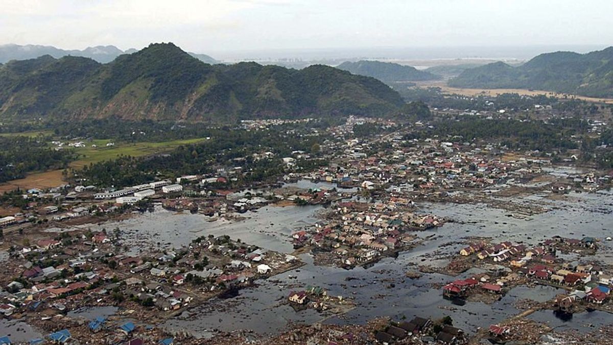
The disaster, known as the Tohoku Earthquake or the Fukushima Earthquake, triggered a tsunami that destroyed cities, and knocked down the Fukushima Daiichi nuclear power plant (PLTN). More than 18,000 people died, mostly as a result of the tsunami, and nearly half a million people were displaced.
The nightmares didn't stop there. The Associated Press (AP) reports that more than 40,000 residents are still unable to return to their homes in Fukushima and its surroundings, due to radioactive contamination.
The 2011 great earthquake and tsunami left many lessons, not only regarding disaster mitigation policies, but also Japan's comprehensive development. They made drastic changes to build national resilience aimed at creating a safe and secure region, and a strong economic community in the face of disasters.
Shunichi Koshimura and Nobuo Shuto in their research "Response to The 2011 Great East Japan Earthquake and Tsunami Disaster" explained that for disaster-affected areas, the central government had changed the policy of coastal protection from the perspective of disaster mitigation. Meanwhile, the local government immediately prepared a reconstruction plan including infrastructure design, transportation, land use management, urban design, relocation, economic and industrial models.
The budget disbursed by the Japanese government was no joke. "Four years have passed since the incident occurred, and a national budget of 25,000 billion yen has been allocated for reconstruction efforts over 5 years," it said.
Japan's real seriousness in mitigating the tsunami disaster is to develop a tsunami early warning system. The Japan Meteorological Agency (JMA), the agency responsible for warning and estimating the range of tsunami wave heights, has been developing a new system since 1999.
This system even continues to be updated within a certain period of time. For this reason, JMA believes that their tsunami early warning system has the best technology in the world. And this warning system has also been adopted by many other countries such as Thailand, Mexico, Peru, and Indonesia is no exception.
"JMA prepared a pre-made tsunami simulation database for more than 100,000 earthquake scenarios across Japan. The contents of the warnings are classified into three categories, according to the estimated tsunami height: 'major tsunami' (estimated at over 3 m), 'tsunami' (estimated at more than 3 m). 1 or 2 m) and 'warning' (0.5 m or less)."
However, no matter how sophisticated the technology, according to Koshimura et al, there are still limitations. "Tsunami warning information can tell people they are in danger, but it cannot guarantee people's safety."
*Read other information about NATURAL DISASTER read another interesting article from Ramdan Febrian Arifin.
Other BERNASThe English, Chinese, Japanese, Arabic, and French versions are automatically generated by the AI. So there may still be inaccuracies in translating, please always see Indonesian as our main language. (system supported by DigitalSiber.id)
Most Popular Tags
#Prabowo Subianto #donald trump #Febrie Adriansyah #8791 #giias 2026Popular


