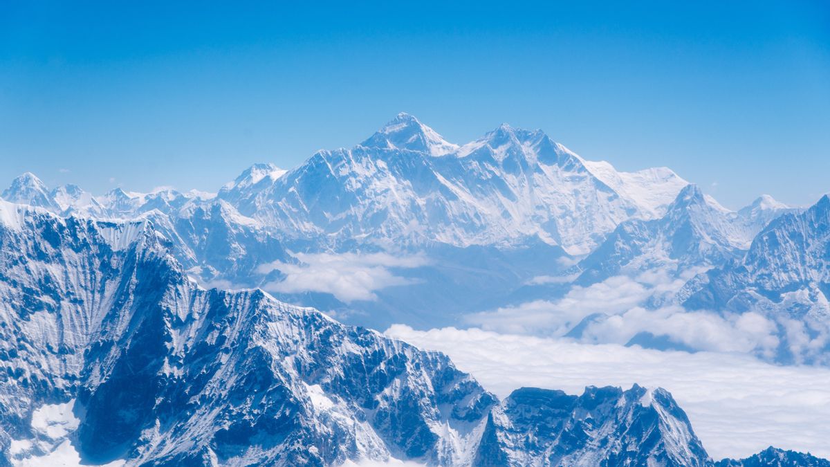


JAKARTA - When talking about the highest mountain in the world, you will definitely remember Mount Everest. However, the height on the mountain is still a puzzle and a debate.
It happened between the two countries, Nepal and China. Previously, Nepal measured Everest's height as 29,028.87 feet (8,848 masl), while China had an elevation of 29,017.16 feet (8,845 masl).
But now the two countries have finally agreed on the true height of Mount Everest, which has an altitude of 8,848.86 masl (29,031.69 feet), an increase of 86 centimeters above sea level, and this report is 2 feet taller which was previously recognized by the Nepalese government.
It is known from a BBC report, Thursday, December 10, that Mount Everest stands on the border between China and Nepal. The hikers who climbed their way through both sides of the country. The agreement to jointly announce the official height of the highest point on Earth was made during Chinese President Xi Jinping's visit to Nepal's capital, Kathmandu, last year.
So Debate?Several years ago, in 2015 there was an earthquake that caused Mount Everest to shrink in height thereafter, according to geologists and killed 9,000 people.
The quake also damaged one million buildings in Nepal and triggered an avalanche that killed 19 people at the base camp.
Scientists have found that several other Himalayan peaks such as the Langtang Himal, mostly north of Kathmandu and close to the epicenter, have decreased in height by approximately one meter after the earthquake.
Others argue that Mount Everest, like other mountains in the Himalayas, may actually be higher over time due to the shifting of tectonic plates it occupies. But experts say a large earthquake can cause the process to reverse.
"The 2015 earthquake was also the main reason why we resized the mountain," said Nepal Survey Department spokesman Damodar Dhakal.

Mount Everest (Alex Copley, University of Cambridge)
The height of Mount Everest was first determined by a British team in 1856 with an altitude of 8,842 masl. However, based on a survey conducted by India in 1954, the correct altitude was 8,848 masl, determined the first time using instruments such as theodolite and GPS.
Quoting Indian Express, the theodolite is a precision instrument for measuring angles in the horizontal and vertical planes, mainly used for special purposes in the fields of meteorology and rocket launch technology.
A modern theodolite consists of a telescope. When the telescope points at a target object, the respective axial angles can be measured with great precision.
Furthermore, in 1999, the National Geographic Society team using GPS technology found that the height of Mount Everest actually reached 8,850 masl.
National Geographic argues that underneath the snow pack is a gray, speckled rock-like expanse, which is 30,000 feet above sea level due to the movement of tectonic plates. The rocks are constantly moving, forming an area the researchers focus on.
In some places, the plates fell apart, creating valleys on the land. In another place, they collided, pushing mountains into the sky one of which was Mount Everest.
Towering on the border of Tibet and Nepal, Mount Everest was formed from the tectonic collision of Indian and Eurasian tectonic plates tens of millions of years ago.
The collision devastated the landscape, raising some 1,500 miles of mountains in what is known as the Himalayan region.
At the same time, as rocks continue to rise upward, erosion hinders their development. Wind and water brushed the surface, sweeping away the sediments of the surrounding mountains and rocks.
Meanwhile, Nepal a few years later used the Bay of Bengal as a base for calculating sea level, but India has surveyed a point closer to Everest, near the India-Nepal border, than the bay, and was able to provide an elevation at that point for Nepalese surveyors.
From there, Nepal built a network of line of sight stations that stretched nearly 250 km until the point Everest was first seen, creating a chain of points that can be measured and added.
Then came China's claim in 2005, which said the height of Mount Everest reached 8,844.43 masl. This is because they do not include the thickness of the ground covered with snow.
Chinese surveyors, however, use the Yellow Sea in the eastern province of Shandong as their sea level base. Surveyors from both countries also used trigonometric formulas to calculate the height of the peaks.
The formula they use calculates the height of a triangle by multiplying its base times its angles. Both parties also use the Global Navigation Satellite System to receive altitude data from various tools in their calculations.
"This is a milestone in mountaineering, which ultimately ends the debate about roof height in the world, because there is only one number," said Nepal Mountaineering Association chairman Santa Bir Lama.
Mount Everest Interesting FactsWho isn't interested in climbing Mount Everest? Not a few climbers make this mountain one of their achievements in terms of climbing mountains.
How not, apart from being the highest mountain in the world, Everest also has other interesting facts that not many people know about. For that, before visiting it, consider the following interesting facts about Mount Everest.
1. Highest Mountain in the World
Mount Everest has the title as the highest mountain in the world. The height of this mountain is 8,848 masl above sea level.
Mount Everest is also called Chomolungma by the Tibetan people which means Mother Goddess of the Universe. The previous Nepalese government also gave the name Sagarmatha, which can be interpreted as the Goddess of Heaven.
2. Included in the Seven Summits of the World
Seven Summits is a series of seven highest mountains on the seven continental plates. The seven mountains are Mount Carstensz Pyramid at an altitude of 4,884 masl in Papua (the Australasian plate), and Mount Elbrus at an altitude of 5,642 masl in Russia (the European plate).
There is also Mount Kilimanjaro, an altitude of 5,895 masl in Tanzania (the African plate), Mount Aconcagua, an altitude of 6,962 masl in Argentina (the South American plate), Mount Vinson Massif, an altitude of 4,892 masl in Antarctica (the Antarctic plate).
Then, Mount Denali at 6,190 masl in Alaska (the North American plate) and Mount Everest at 8,848 masl in Nepal (the Asian plate).
3. Has 18 climbing routes
Mount Everest is located on the Asian Continent plate. In the south is bordered by Nepal, in the north by China and Tibet. There are about 18 alternative hiking trails on Mount Everest.
4. The Oxygen Is So Thin
When you are at the top of Everest, oxygen will continue to decline by a third. The higher the sea level, the lower the air pressure. The low air pressure makes oxygen spread so that less.
In order to avoid lack of oxygen during the climb, climbers are advised to carry oxygen cylinders when climbing to the top of Everest.
5. Terrain is Very Heavy and Rugged
In addition to the thinness of oxygen on Mount Everest, climbers must also be prepared to pass through tough terrain. Like a cliff with steep ravines on the right and left. The temperature can also reach minus 80 degrees Fahrenheit.
6. Sherpas Often Help
The Sherpa tribe living in West Nepal will usually help climbers. Because the Sherpa people are used to the extreme heights in Nepal. Usually they help bring hiking and cooking equipment at the camp.
7. Indonesian Women Successfully Reached the Top of Everest
Yes, it is known that the first two Indonesian women made it to the top of Mount Everest and raised the Indonesian flag.
They are Fransiska Dimitri Inkiriwang (Deedee) and Mathilda Dwi Lestari (Hilda) who are members of The Women of Indonesia's Seven Summits Expedition Mahitala Unpar (WISSEMU) team.
This Indonesian heroine managed to set foot on the highest point in the world on May 17, 2018, precisely at 05.50 local time or around 07.05 WIB.
The two also made the peak of Mount Everest, the last mountain they had reached to fly the Indonesian flag on the seven highest mountains on seven continents.
The English, Chinese, Japanese, Arabic, and French versions are automatically generated by the AI. So there may still be inaccuracies in translating, please always see Indonesian as our main language. (system supported by DigitalSiber.id)


