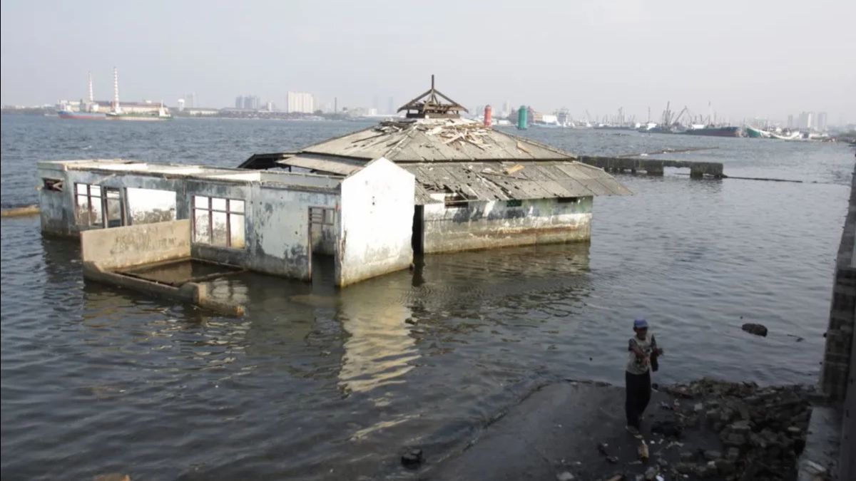


JAKARTA - Land subsidence in Jakarta continues, especially in the northern coastal area. The DKI Jakarta Provincial Government recorded the rate of land subsidence in the last two years at a range of 0 to 9 centimeters (cm) per year, with different variations in each area.
The Head of the Planning Subgroup for Rob Control and Coastal Development of the DKI Jakarta Water Resources Office, Alfan Widyastanto, said that North Jakarta was the area most affected by the phenomenon.
"Based on records, land subsidence in Jakarta is still occurring, especially in the North Jakarta area. The average land subsidence in the last 2 years ranges from 0-9 cm per year, although the figures are different in each region," said Alfan in his statement, Thursday, January 15.
According to Alfan, one of the dominant factors that triggers land subsidence is the massive extraction of groundwater. Groundwater exploitation causes compaction in the aquifer layer which has a direct impact on land surface subsidence.
"Groundwater extraction is one of the causes of land subsidence in Jakarta. Because, when groundwater is exploited, there will be soil compaction in the aquifer which causes the land on the surface to experience a decrease," said Alfan.
He reminded that if the condition is left, the impact will not only be felt in coastal areas, but also on city buildings and infrastructure. Land subsidence has the potential to cause buildings to crack and tilt, water channels to not function optimally, and road damage.
The coastal area is said to be a priority for handling because the impact is most visible. A number of areas in North Jakarta, northwest, and northeast are recorded as areas with high risk.
"Areas adjacent to the beach are the most affected by land subsidence, including several areas in the north, northwest, and northeast of Jakarta, namely Cengkareng, Penjaringan, Mutiara Beach, Pantai Indah Kapuk, Ancol, Cilincing to the Cakung area," said Alfan.
As a mitigation step, the DKI Jakarta Provincial Government has tightened the extraction of groundwater through the implementation of a groundwater-free zone (zobat). This policy restricts and even prohibits the use of groundwater in certain areas by considering the aquifer conditions and the availability of piped water.
The ban is regulated in the DKI Jakarta Governor's Regulation Number 93 of 2021 concerning the Land Water Free Zone. Currently, zobat covers nine areas and 12 major roads in Jakarta, including business and industrial areas.
In addition, the DKI Provincial Government also plans to expand the implementation of zobat in a number of areas in North Jakarta, such as Jalan Letjen Soeprapto, Jalan Perintis Kemerdekaan, and the Kelapa Gading area.
On the other hand, the local government targets the strengthening of piped water services as the main alternative to groundwater.
Alfan emphasized that if land subsidence is not controlled, the risks faced by Jakarta will be greater, especially related to flooding.
"Land subsidence has a very significant impact on people's lives. In terms of the impact on the environment, land subsidence can expand the flood-prone area because the water channels do not function due to the emergence of basin areas," he said.
He added that land subsidence in coastal areas also increases the potential for flash floods, so additional control systems such as pumps and polders are needed.
To reduce this risk, the DKI Jakarta Provincial Government together with the central government also carried out other mitigation projects, including the construction of coastal protection embankments through the National Capital Integrated Coastal Development (NCICD) program, as well as accelerating the community's transition to piped drinking water.
Previously, the National Research and Innovation Agency (BRIN) said that the land subsidence in Jakarta, especially the northern area, was a combination of natural geological processes and human activities.
Naturally, the North Jakarta area is composed of alluvial soil that does experience compaction over time. However, this process is accelerated by massive groundwater extraction and has been going on for decades.
BRIN researchers explained that the extraction of groundwater evenly, both by settlements, commercial areas, and industries, causes the soil layer to consolidate and fall simultaneously.
In the mid-1970s, the northern area of Jakarta was still about one meter above sea level. Now, a number of points are actually up to about three meters, even more, below sea level.
The continued land subsidence without being noticed has triggered various serious impacts, one of which is the increasingly frequent flash floods. This condition shows that the problem of land subsidence is not only a technical issue, but also has a direct impact on the sustainability of Jakarta as a livable city.
The English, Chinese, Japanese, Arabic, and French versions are automatically generated by the AI. So there may still be inaccuracies in translating, please always see Indonesian as our main language. (system supported by DigitalSiber.id)


