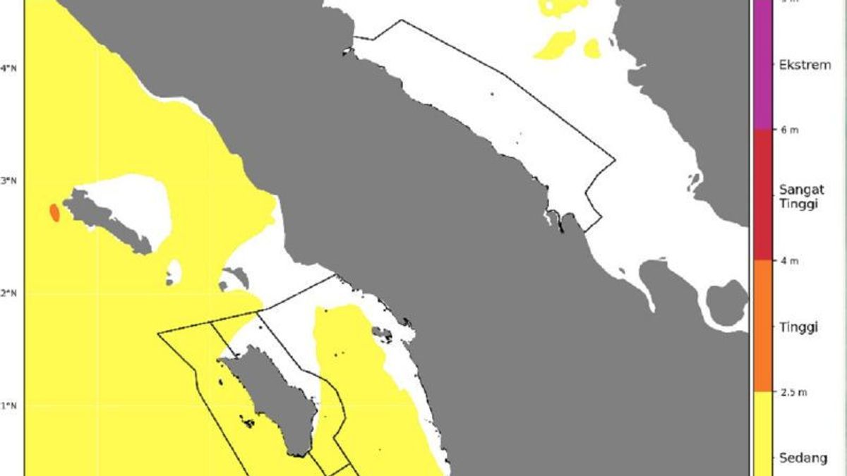


JAKARTA - Maritime Class II Meteorological Station Belawan Medan, North Sumatra (North Sumatra), said that a number of waters in the North Sumatra region have the potential to be hit by high waves that can disrupt shipping.
"This condition has the potential to occur from November 4 to 6, 2025," said Maritime Class II Meteorological Station forecaster Belawan Medan Indah Riandiny Puteri in Medan City, Tuesday, as reported by Antara.
The sea waves as high as 1.25 to 2.5 meters have the potential to occur in the western waters of North Sumatra, the western waters of the Nias Islands, the western waters of the Nias Islands, the waters of the Batu Islands, and the western Indian Ocean of the Nias Islands.
Wind patterns in northern Indonesia generally move from northwest to southwest with wind speeds ranging from four knots, while in southern Indonesia, they generally move from east to south with wind speeds ranging from 4-25 knots.
The highest wind speed was observed in the Makassar Strait.
To stakeholders are reminded to be aware of the potential for high waves. If the wind speed reaches 15 knots and the sea wave height reaches 1.25 meters, he said, it is risky for shipping using fishing boats.
Wind speeds reach 16 knots and high waves reaching 1.5 meters have a risk to the shipping safety of barges, while wind speeds reach 21 knots and high waves reach 2.5 meters, at risk of the ferry shipping safety.
SEE ALSO:
-
 | BERITA
Kasus Korupsi Anoda Logam, KPK Panggil 4 Saksi Termasuk CEO Office Senior Specialist Antam
03 November 2025, 14:34 -
 | BERITA
Adu Banteng Truk-Bus Berpenumpang 70 Orang di India, 20 Orang Tewas
03 November 2025, 17:04 -
 | BERITA
Iran Anggap Sepele Trump, Siap Bangun Lagi 3 Situs Nuklir yang Dibombardir AS
03 November 2025, 00:09 -
 | BERITA
Rusia Dukung Venezuela Lawan Militerisme Trump di Karibia, Tuduh AS Langgar Piagam PBB
03 November 2025, 01:54

The English, Chinese, Japanese, Arabic, and French versions are automatically generated by the AI. So there may still be inaccuracies in translating, please always see Indonesian as our main language. (system supported by DigitalSiber.id)
Most Popular Tags
#Prabowo Subianto #donald trump #Febrie Adriansyah #8791 #giias 2026Popular


