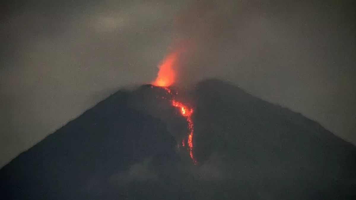


JAKARTA - Mount Semeru in East Java (East Java) erupted with an eruption observed up to a height of 1 kilometer (km) above the peak or 4,676 meters above sea level (masl) on Sunday 7 July at 04.58 WIB.
"The ash column was observed to be gray with thick intensity to the north and northwest. The eruption was recorded on a seismograph with a maximum amplitude of 23 mm and a duration of 137 seconds," said Mount Semeru Observation Post Officer Ghufron Alwi in a written statement, Sunday 7 July, confiscated by Antara.
Based on data, the mountain, which is located on the border of Lumajang and Malang Regencies, on Sunday, July 7 morning experienced several eruptions, namely at 00.48 WIB with visual eruptions not being observed, but the eruption was recorded on a seismograph with a maximum amplitude of 22 mm and a duration of 99 seconds.
Then at 01.18 WIB with visual eruptions were not observed, but this eruption was recorded on a seismograph with a maximum amplitude of 22 mm and a duration of 118 seconds.
The mountain, which has an altitude of 3,676 meters above sea level, erupted again at 02.29 WIB and the eruption visual was not observed, but the eruption was recorded on a seismograph with a maximum amplitude of 22 mm and a duration of 133 seconds.
Furthermore, the eruption returned at 04.07 WIB and the eruption visual was not observed. The eruption was recorded on a seismograph with a maximum amplitude of 23 mm and a duration of 132 seconds.
Visual eruptions can only be seen during the eruption at 04:58 WIB as high as 1,000 meters and at 05.40 WIB with a column height of volcanic ash eruptions observed 500 meters above the peak.
"The ash column was observed to be white to gray with thick intensity to the north. The eruption was recorded on a seismograph with a maximum amplitude of 22 mm and a duration of 122 seconds," said Ghufron.
SEE ALSO:


From January 1, 2024 to July 7, 2024, at 07.00 WIB, the highest mountain on the island of Java experienced 664 eruptions or eruptions with alert status or level III.
For this reason, the Center for Volcanology and Geological Hazard Mitigation (PVMBG) recommends that people do not carry out any activities in the southeast sector along Besuk Kobokan as far as 13 kilometers from the summit (the center of the eruption).
Then outside of that distance, the community is also advised not to carry out activities at a distance of 500 meters from the riverbank (river border) along Besuk Kobokan, because it has the potential to be affected by the expansion of hot clouds and lava flows up to a distance of 17 km from the summit.
Residents are also prohibited from doing activities within a five-kilometer radius of the crater/peak of Mount Semeru, because they are prone to the danger of throwing stones (pijar).
The public is also asked to be aware of the potential for hot clouds, lava avalanches, and lahars, along rivers/valleys that originate at the peak of Mount Semeru, especially along Besuk Kobokan, Besuk Bang, Besuk Kembar, and Besuk Sat, as well as the potential for lahars in small rivers that are tributaries of Besuk Kobokan.
The English, Chinese, Japanese, Arabic, and French versions are automatically generated by the AI. So there may still be inaccuracies in translating, please always see Indonesian as our main language. (system supported by DigitalSiber.id)


