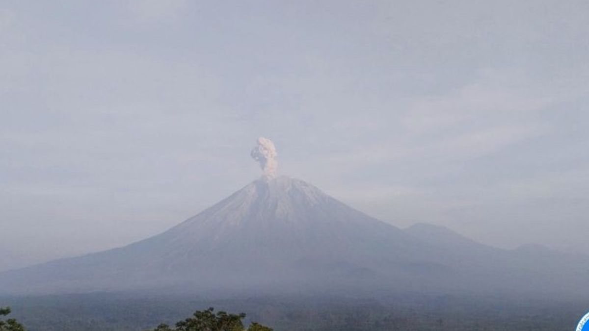


JATIM - Mount Semeru experienced six eruptions continuously accompanied by eruptions that ejected volcanic ash as high as 400-900 meters above the peak on Friday, May 24 morning.
The first eruption of the mountain on the border of Lumajang Regency with Malang, East Java (Jatim) occurred at 00.04 WIB, followed by the second eruption at 01.37 WIB.
The eruption of the mountain, which has a height of 3,676 meters above sea level (masl), then occurred at 02.26 WIB, 03.41 WIB, 05.27 WIB, and the sixth eruption occurred at 06.12 WIB with an eruption height of volcanic ash from 400 meters to 900 meters above the peak.
"There was an eruption of Mount Semeru on Friday, May 24, 2024, at 06.12 WIB with a height of volcanic ash column observed about 900 meters above the peak or 4,576 meters above sea level," said Mount Semeru Observation Post Officer Sigit Rian Alfian in a written statement, Friday, May 24, confiscated by Antara.
According to him, the column of volcanic ash was observed to be white to gray with thick intensity to the southeast. The eruption was recorded on a seismograph with a maximum amplitude of 23 mm and a duration of 137 seconds.
Previously, the eruption occurred at 05.27 WIB with a column height of ash observed about 500 meters above the peak or 4,176 mdpl. The ash column was observed to be white to gray with thick intensity to the east and southeast. The eruption was recorded on a seismograph with a maximum amplitude of 22 mm and a duration of 122 seconds.
Meanwhile, the Head of Emergency and Logistics Division of the Lumajang Regency BPBD, Yudi Cahyono, said that there was an eruption of Mount Semeru every day and that active mountain activity was considered reasonable in line with its status at level III or standby.
"Indeed, it is dangerous if there is no eruption every day, because there is a magma deposit which is possible that there will be a fairly large eruption. People on the slopes of Mount Semeru already understand the character of the volcano," he said.
SEE ALSO:


The Center for Volcanology and Geological Hazard Mitigation (PVMBG) provides recommendations so that people do not carry out any activities in the southeast sector along Besuk Kobokan as far as 13 km from the summit (the center of the eruption).
Beyond this distance, the community is also advised not to carry out activities at a distance of 500 meters from the riverbank (river border) along Besuk Kobokan because it has the potential to be affected by the expansion of hot clouds and lava flows up to a distance of 17 km from the summit.
Then, residents are also prohibited from doing activities within a 5 km radius from the crater/peak of Mount Semeru, because they are prone to the danger of throwing stones (lightning).
The public is also asked to be aware of the potential for hot clouds, lava avalanches, and lahars along rivers/valleys that originate at the peak of the Semeru Volcano, especially along Besuk Kobokan, Besuk Bang, Besuk Kembar, and Besuk Sat as well as the potential for lahars in small rivers that are tributaries of Besuk Kobokan.
The English, Chinese, Japanese, Arabic, and French versions are automatically generated by the AI. So there may still be inaccuracies in translating, please always see Indonesian as our main language. (system supported by DigitalSiber.id)


