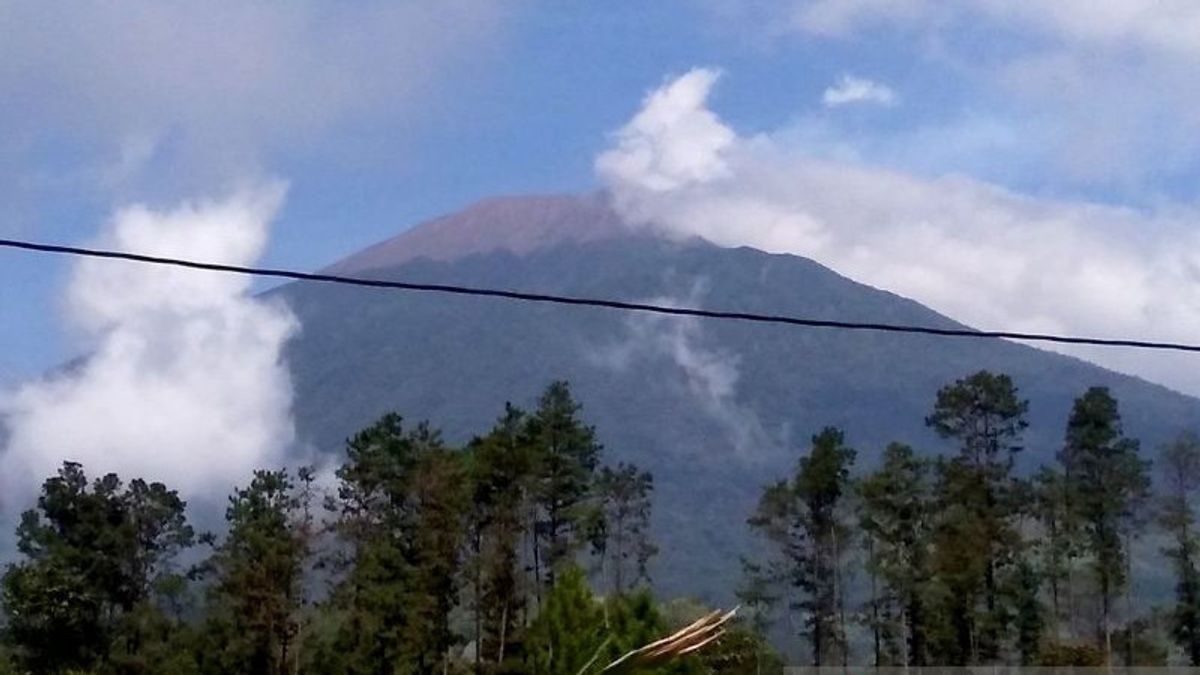
PURBALINGGA - Head of the Purbalingga Regency Youth and Tourism Office (Dinporapar) R Budi Setiawan ensured that all tourist attractions in Purbalingga, Central Java, are safe for tourists because they are quite far from the danger radius of the eruption of Mount Slamet.
"We have coordinated with all tourist attraction managers in Purbalingga regarding the expansion of the eruption hazard radius of Mount Slamet to 3 kilometers from the top crater of the mountain," said Budi Setiawan in Purbalingga, Antara, Friday, May 17.
Based on the results of this coordination, it can be ascertained that the tourist objects are safe to be visited by tourists because they are far from the danger radius of the eruption of Mount Slamet.
In this case, he gave an example of two tourist attractions that are quite close to the peak of Mount Slamet, namely the Asri Serang Valley Tourism Village (D'LAS) and Goa Lawa Purbalingga (Golaga).
"D'LAS is about 5 kilometers from the summit of Mount Slamet, while Golaga is about 6-7 kilometers away. Even this Friday (17/5), many tourists from various areas such as Cilacap Regency visited D'LAS, activities were running normally," he said.
In addition, he said, the activities of residents of Gunungmalang Village continue to run normally even though the distance from villages that are often visited by tourists is close to the peak of Mount Slamet.
Nevertheless, he said the climbing route of Mount Slamet through Dukuh Bambangan, Kutawawa Village, Karangreja District, had been closed since the largest increase in mountain activity on the island of Java.
Asked about the preparation for the 2024 Mount Slamet Festival (FGS), Budi said that until now it continues according to plan because the annual tourism activity which will be held in Serang Tourism Village on July 12-14 has become part of Kharisma Event Nusantara (KEN) in 2024.
"We also invite local districts to participate in enlivening these activities," he said.
On a separate occasion, the Head of Tourism for the Cultural and Tourism Youth Office (Dinporabudpar) of Banyumas Wardoyo Regency said that tourist attractions in Banyumas, especially those at the foot of Mount Slamet, remain safe for tourists to visit.
According to him, this was due to the distance of the tourist attraction which was quite far from the danger radius of the eruption of Mount Slamet.
"For example, tourist attractions in Baturraden District such as Baturraden Lokatawisata are about 12 kilometers from the top of Mount Slamet, so it is still safe for tourists to visit," he said.
In this regard, he appealed to tourism actors around Baturraden to remain calm and carry out activities as usual.
In addition, he said, prospective tourists who want to travel to Baturraden are advised not to be provoked by information that cannot be justified related to Mount Slamet's volcanic activity.
"We always coordinate with various parties related to the development of Mount Slamet's volcanic activity," said Wardoyo.
The Geological Disaster Volcanology and Mitigation Center (PVMBG) of the Geological Agency has raised the level of activity of the Slamet Volcano from Level I (Normal) to Level II (Alert) starting October 19, 2023, at 08.00 WIB, and recommended that people and tourists not be active within a 2 kilometer radius of the summit crater of Mount Slamet.
Furthermore, on Thursday (16/5), the Geological Agency expanded its recommendation distance to 3 kilometers from the summit crater of Mount Slamet even though the mountains located in the districts of Banyumas, Purbalingga, Pemalang, Tegal and Brebes are still Alert or Level II.
The expansion of the recommendation distance was carried out because based on the results of observations of monitoring data, it showed an increase in pressure under Mount Slamet which could trigger shallow earthquakes or eruptions.
The potential threat of the danger of Mount Slamet is currently in the form of a phreatic and magnesium eruption that can produce the ejection of incandescent material that hit the area around the peak within a radius of 3 kilometers.
In addition, ash rain can occur around craters or hit areas determined by wind direction and speed.
SEE ALSO:
The English, Chinese, Japanese, Arabic, and French versions are automatically generated by the AI. So there may still be inaccuracies in translating, please always see Indonesian as our main language. (system supported by DigitalSiber.id)
Most Popular Tags
#Prabowo Subianto #New Year #airplane accident #Hasto Kristiyanto #nataru #squid game 2Popular
03 Januari 2025, 06:15
03 Januari 2025, 00:02
03 Januari 2025, 07:35
03 Januari 2025, 04:00


