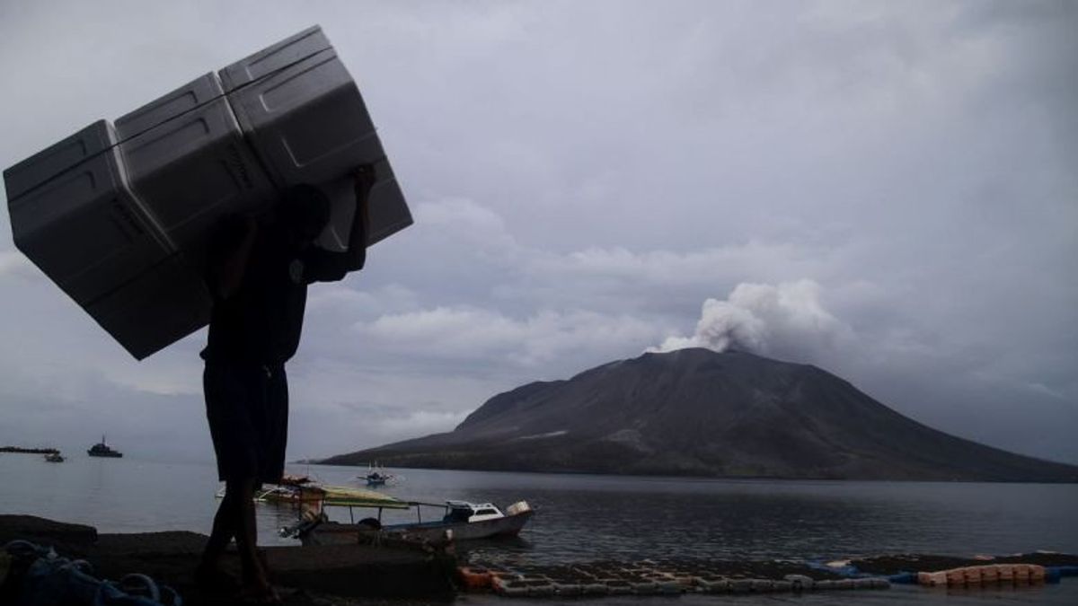


JAKARTA - Mount Ruang with a type of strato in Sitaro Regency, North Sulawesi, stores the potential danger of hot clouds to lava floods that local residents around the area need to watch out for.
"The current potential danger is in the form of an eruption that produces hot clouds, incandescent material, and exposure to volcanic ash that depends on the direction and speed of the wind and lahar when heavy rains fall around Mount Ruang," said Head of the Geological Agency Muhammad Wafid as reported by ANTARA, Thursday, May 2.
Wafid said that visual observations of Mount Ruang in the period from April 22 to May 2, 2024, generally have sunny to rainy weather.
The wind blows weakly to moderate to the north, northeast, east, south, southwest, west, and northwest with an air temperature of about 22 to 32 degrees Celsius.
The eruption activity that occurred on April 17 and April 30, 2024, damaged a seismic station 1.5 kilometers and 2.7 kilometers from the crater center.
The two eruptions caused the activity of recording volcanic activity to be disrupted due to the distance from the Mount Ruang Observation Post as far as 5 kilometers from the crater center.
On May 1, 2024, volcanic activity on Mount Ruang was dominated by continuous tremors despite three deep volcanic earthquakes and 10 shallow volcanic earthquakes.
The eruption occurred at 17.43 WITA with a column height of about 600 m above the peak. The ash column was observed to be white to gray with moderate to thick intensity leaning towards the north.
On May 2, 2024, until 09.00 WITA, volcanic activity was still dominated by tremors. The Geological Agency noted that there were four shallow volcanic earthquakes, two local tectonic tempa, and two tectonic tempa.
The crater smoke is white and gray with moderate to thick intensity. The height of smoke ranges from 300 to 500 meters from the top of the crater.
In the alert status which is now embedded in Mount Ruang, residents are asked not to enter a radius of seven kilometers from the center of the active crater.
SEE ALSO:


Mount Ruang, which has an altitude of 725 meters above sea level, is administratively located in Tagulandang District, Sitaro Islands Regency, North Sulawesi Province.
Monitoring activities are carried out visually and instrumentally through a volcanic observation post located in Tulusan Village, Tamulandang District, Sitaro Islands Regency, North Sulawesi Province.
The history of the eruption of Mount Ruang has been recorded since 1808 and has an eruption interval ranging from 1 to 30 years.
The last eruption of the type A cone volcano, before the eruption in 2024, occurred in 2002 which was an explosive eruption accompanied by hot clouds and resulted in land and settlement damage and required population evacuation.
The English, Chinese, Japanese, Arabic, and French versions are automatically generated by the AI. So there may still be inaccuracies in translating, please always see Indonesian as our main language. (system supported by DigitalSiber.id)
Most Popular Tags
#Prabowo Subianto #donald trump #2026 World Cup #venezuela #konflik timur tengahPopular


