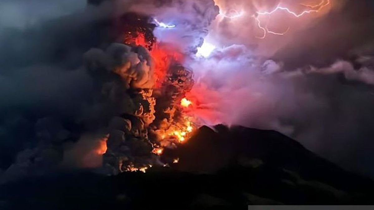
JAKARTA Volcanic ash is still disturbing the air in Manado City, North Sulawesi Province due to the eruption of Mount Ruang.
Head of the BNPB Disaster Data, Information and Communication Center Abdul Muhari in his written statement, Friday, April 19, this condition had an impact on the safety and security of flights at Sam Ratulangi Airport and there was no electricity in Lumbo Village on Tagulandang Island, aka being paralyzed.
After the explosive eruption, the electricity and communication network was paralyzed in Laing Patehi Village, which is located on Ruang Island. Meanwhile, in Lumbo Village on Tagulandang Island, the condition of the communication network is not functioning optimally.
The refugees that have been recorded by BPBD are on Tagulandang Island totaling 272 families or 838 people.
Those from Laingpatehi Village amounted to 166 families (506 people) and Pumpente Village 106 families (332 people).
Meanwhile, he said, the evacuation of residents was also carried out on the people on the island of Tamulandang, especially on the west side who were dealing with the Island of Ruang.
Data collection is still being carried out by the local government, with temporary data totaling 6,045 people. They come from Bahoi Village and Balehumara Village.
Based on the dashboard of the volcano monitoring information system, Mount Ruang was clearly visible until it was covered in fog today (19/4).
Observed white main crater smoke with moderate to high intensity of about 50-100 meters from the top of the mountain. Cloudy weather, weak winds to the south.
The volcanic authority, Center for Volcanology and Geological Hazard Mitigation (PVMBG), has set the status of Mount Ruang volcanic activity at the highest level or IV (Awas) on Wednesday, April 17, at 21.00 WITA.
Recommendations at that level include (1) people around Mount Ruang and visitors/tourists to remain vigilant and not enter a radius of 6 km from the center of the active crater of the mountain, (2) people who live in the Tagulandang Island area which is within a 6 km radius to be immediately evacuated to a safe place outside the 6 km radius, (3) people on Tagulandang Island, especially those living near the coast, to be aware of the potential for incandescent rock eruptions, hot clouds (surge), and tsunamis caused by the collapse of the volcanic body into the sea, and (4) people are advised to always use masks, to avoid volcanic ash exposure that can disrupt the respiratory system.
The airport authority (airport) has also issued a notification regarding this condition.
The eruption that occurred last Tuesday (16/4) had an impact on the operational closure of Sam Ratulangi International Airport in Manado City, North Sulawesi Province.
The airport, which is about 95 km from Mount Ruang, is still temporarily closed. The National Disaster Management Agency (BNPB) monitors the closure of the airport being extended to this day, Friday (19/4), at 06.00 p.m. 18.00 p.m. local time.
The distribution of volcanic ash from Mount Ruang was observed in North Minahasa Regency on Thursday (18/4). A number of sub-districts were affected by volcanic ash, including West Likupang, Wori, East Likupang and South Likupang Districts.
The Regional Disaster Management Agency (BPBD) of North Minahasa Regency appealed to residents to wear masks and remain calm, especially in responding to hoax information.
Information development on Thursday night (18/4), at 23.00 WIB, BNPB monitors that the Tagulandang Port is currently being operated for the mobilization of evacuation and distribution of aid to affected communities.
The local government of the Siau Islands Islands Regency, Tagulandang Biaro (Sitaro) has activated a command post located in Apengsala Village. This des is 15 km from Mount Ruang.
The English, Chinese, Japanese, Arabic, and French versions are automatically generated by the AI. So there may still be inaccuracies in translating, please always see Indonesian as our main language. (system supported by DigitalSiber.id)


