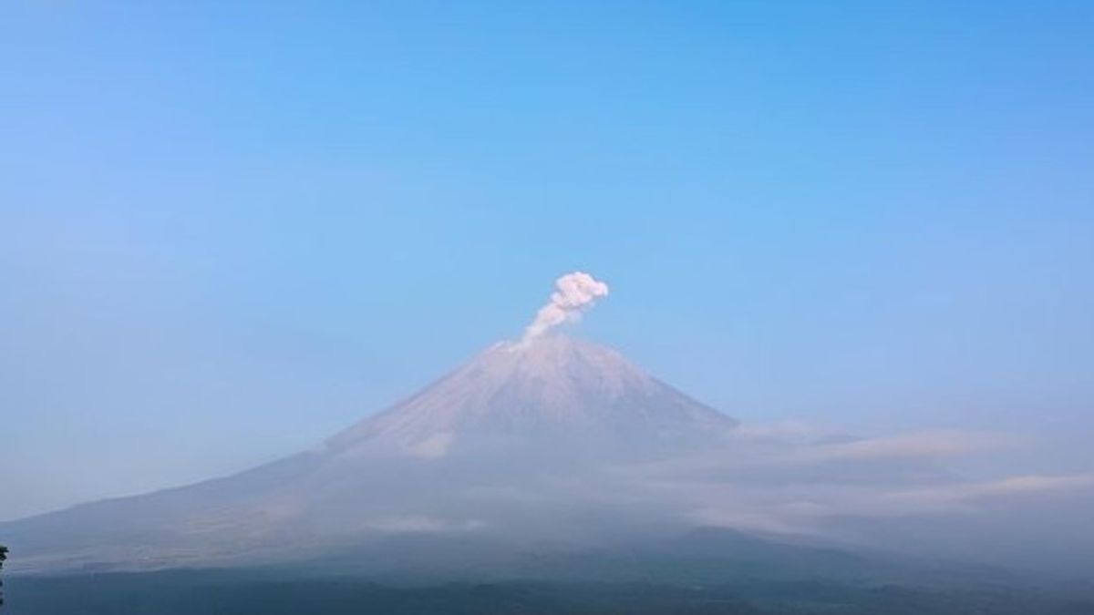


JAKARTA - Mount Semeru, located in Malang Regency and Lumajang Regency, East Java Province, erupted and ejected volcanic ash as high as approximately 1,000 meters or 1 Kilometer above the top of the highest volcano on the island of Java. Mount Semeru Observation Post officer Sigit Rian Alfian said the eruption occurred this morning at 06.28 WIB resulting in a column of white to gray ash towards the northeast. "The eruption was recorded on a seismograph with a maximum amplitude of 22 millimeters and a duration of 101 seconds," said Sigit in a report received by ANTARA, Thursday, February 15. This morning during the period 00.00 to 06.00 WIB, the Center for Volcanology and Geological Hazard Mitigation (PVMBG) through the Magma Indonesia website noted that Mount Semeru had experienced two eruptions. The eruption occurred at 01.13 WIB with a height of volcanic ash columns of approximately 700 meters leading north. The maximum amplitude of the eruption was 22 millimeters with a duration of 143 seconds.
Furthermore, the eruption which was also recorded at 04.59 WIB with a column height of ash reaching approximately 800 meters led to the northeast. Seismogram equipment noted that the eruption had a maximum amplitude of 22 millimeters and a duration of 132 seconds.PVMBG appealed to the public not to carry out any activity in the southeast sector along Besuk Kobokan as far as 13 kilometers from the center of the eruption. Outside that distance, people are also not allowed to carry out activities at a distance of 500 meters from the river bank (river border) along Besuk Kobokan because it has the potential to be affected by the expansion of hot clouds and lava flows up to a distance of 17 kilometers from the summit. PVMBG also appealed to the public not to move within a radius of five kilometers from the summit of Mount Semeru because it is prone to the danger of throwing stones.
SEE ALSO:
-
 | EKONOMI
5 Strategi Menjaga Kondisi Bisnis Tetap Stabil Menghadapi Persaingan dan Tantangan Zaman
15 Februari 2024, 06:10

Hot clouds, lava avalanches, and lahars, need to be watched out for along rivers or valleys that originate at the top of Mount Semeru, especially along Besuk Kobokan, Besuk Bang, Besuk Kembar, and Besuk Sat, as well as the potential for lava in small rivers that are tributaries from Besuk Kobokan.
The English, Chinese, Japanese, Arabic, and French versions are automatically generated by the AI. So there may still be inaccuracies in translating, please always see Indonesian as our main language. (system supported by DigitalSiber.id)
Most Popular Tags
#Prabowo Subianto #donald trump #2026 World Cup #Febrie Adriansyah #8791Popular


