

PACITAN - Head of the Regional Disaster Management Agency for Pacitan Regency, East Java, Erwin Andriatmoko, appealed to the public not to worry, let alone panic, with information on the findings of a seamount in local waters.
"The mountain is true, but it has nothing to do with the seismic activity that has occurred in the Pacitan area so far. So (should) the public need not worry," said Erwin in Pacitan, as reported by ANTARA, Monday, February 20.
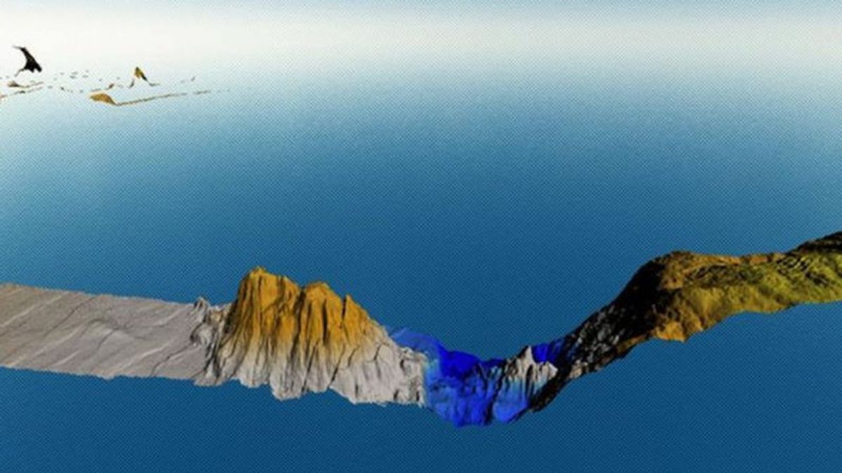
Erwin emphasized this following the viral news of the discovery of a seamount at a depth of 3-4 kilometers below sea level, 200 kilometers southwest of Pacitan City.
He emphasized that the mountain, which was identified by the Geospatial Information Agency (BIG) as having a height of about 2,300 meters from the seabed, had existed for a long time, but its existence was only recently discovered.
"Never before has a mountain appeared in history, let alone a mountain that big all of a sudden. In the sense of an earthquake process. It means that the mountain has existed for a long time, only recently described or just discovered," he explained.
With that basic logic, Erwin ensured that there was no connection between the existence of the seamount and the seismic activity that often occurs and is felt in the Pacitan area.
Erwin admitted that he had coordinated with officials/officers at BIG who specifically deal with mountain issues.
And from the discussion via telephone at that time, Erwin concluded that the formation of a seamount in the southwest of Pacitan Regency was formed due to the collision of two earth plates that occurred millions of years ago.
"The mountain was formed due to plate folding activity. It's the same as Mount Jaya Wijaya, Mount Everest. If you look at its history, Everest used to be an ocean, now it's the highest mountain in the world. So it's all the same, that it was formed due to natural folding processes that have occurred millions of years ago, so a mountain like that was formed," he explained.
Related to the threat of the impact of the presence of seamounts in Pacitan waters, Erwin said this was a separate problem. The reason is until now he said there was no technology that could monitor volcanic activity as deep as more than 500 meters below sea level.
"That's a particular difficulty. So you can't monitor volcanic activity. (So far) the only one is like mountains in North Sulawesi, and even then it can't be maximized. Because the tools can't function perfectly. Only in North Sulawesi is volcanic activity (under the sea) can be identified from the increase in bubbles around the mountain and the phenomenon of massive fish death," he continued.
SEE ALSO:
-
 | BERITA
Polri Sebut Dosen UII Tidak Hilang, Tapi Sengaja Menghilang dengan Ubah Rute
20 Februari 2023, 10:27 -
 | BERITA
Tim SAR Capai Lokasi Kecelakaan Helikopter Kapolda Jambi, Mulai Berupaya Evakuasi
20 Februari 2023, 10:20 -
 | BERITA
Brimob Kawal Ketat Proses Bupati Nonaktif Mamberamo Tengah Dibawa ke Jakarta
20 Februari 2023, 07:51
Therefore residents are asked not to fret or panic too much. Because according to him, in the history of volcanology in Indonesia and in the world, there has never been a volcano (volcanological activity) that could cause an earthquake that triggers a tsunami except in Tonga, around the Fiji Islands.
"Mount Tonga is active because the mountain is large, causing a big earthquake (and triggering a tsunami)," he said.
Erwin added, currently what needs to be watched out for is the potential for tectonic activity from the earth's plates which have been forming mountains.
"So what we need to watch out for is not volcanic activity from the mountain, if it is indeed a volcano, it's just that until now we haven't gotten certainty whether it's a volcano or not. But even if it's a volcano we should be more aware of the potential for plate activity on the coast. south, because that's the only thing that can cause a tsunami," he said.
The English, Chinese, Japanese, Arabic, and French versions are automatically generated by the AI. So there may still be inaccuracies in translating, please always see Indonesian as our main language. (system supported by DigitalSiber.id)


