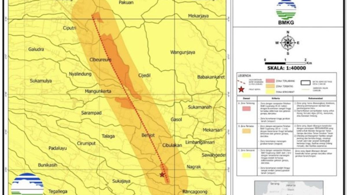


JABAR - The Meteorology, Climatology and Geophysics Agency (BMKG) issued a map of the threat of an earthquake in Cianjur, West Java (West Java). The map is divided into a number of danger zones.
The danger zone consists of three vulnerability zones for ground movement, namely the forbidden zone (red), the limited zone (orange), and the conditional zone (yellow).
The prohibited zone has an area of 2.63 square km covering four sub-districts and 12 villages, spread from Cilaku District, especially in parts of Rancagoong Village, Cianjur District; part of Nagrak Village, Cugenang District.
This includes some of the villages of Cibulakan, Benjot, Sarampad, Gasol, Mangunkarta, Cijedil, Nyalindung and Cibeureum, Pacet District; and some of Ciputri and Ciherang villages.
The forbidden zone has zone criteria with an active fault border of Cugenang 0-10 meters to the right and to the left perpendicular to moving faults, which are very high vulnerability zones due to earthquake deformations and vibrations, or are zones of high vulnerability for landslides or landslides.
Based on the Antara report, BMKG recommended that the prohibited zone be vacated from the existence of buildings through the relocation program, prohibited rebuilding, and new development to prioritize the use of Green Open Space (RTH), monuments or protected areas.
The limited zone has an active fault border of 10 meters to 1 kilometer to the right and to the left perpendicular to moving faults, is a high vulnerability zone due to deformation and earthquake vibrations, or is a medium vulnerability zone for ground movement.
The recommendations for the zone can be built by implementing very strict requirements for earthquake-resistant building standards, as well as prohibited the construction of very important and high-risk facilities, such as hospitals and high-rise schools, energy facilities (oil refineries), and similar facilities.
The conditional zone has criteria with an active fault border of Cugenang more than 1 kilometer to the right and to the left perpendicular to moving faults, which is a medium to low vulnerability zone.
BMKG recommendations include building construction that is earthquake-resistant or soil-resistant.
BMKG said that the earthquake hazard map triggered by Patan Cugenang could be used in reconstruction and rehabilitation efforts in Cianjur Regency, as well as a reference for improving spatial planning in the Cugenang District, in order to prevent damage to buildings, the environment or casualties.
The English, Chinese, Japanese, Arabic, and French versions are automatically generated by the AI. So there may still be inaccuracies in translating, please always see Indonesian as our main language. (system supported by DigitalSiber.id)
Popular


