

JAKARTA - Head of the Geological Agency of the Ministry of Energy and Mineral Resources (ESDM), Eko Budi Lelono, said the eruption of Mount Semeru was related to high rainfall around the top of the mountain, causing the lava lip to collapse which triggered an eruption.
"It seems that there is indeed a connection with high rainfall, causing the lava lip to collapse, triggering an eruption, or hot clouds falling", Eko said, quoted by Antara, Saturday, December 4.
Eko explained that the eruption of Mount Semeru on Saturday afternoon was most likely from external factors, namely high rainfall. This is because the record of relatively low seismicity and the activity of magma and material supply throughout November and from December 1 to 3, 2021 did not experience significant changes.
"In terms of seismicity, this is relatively low, there is no association with an increase in the supply of magma or surface rocks. The activity of Mount Semeru is actually not excessive activity from the earthquake, which shows that the supply of magma is relatively normal as before", said Eko.
He said his team at the observation post in the field monitors the activity of Mount Semeru for 24 hours to observe if at any time there is an increase.
"If at any time there is an increase in the activity of Mount Semeru, we will inform you, coordinate with the ladies and gentlemen from BPBD (Regional Disaster Management Agency), BNPB (National Agency for Disaster Management), and local governments so that they can anticipate further actions", he said.
SEE ALSO:
-
 | BERITA
Resmikan Monumen Pahlawan COVID-19, Wapres Harap Sistem Kesehatan RI Jadi Lebih Tangguh
04 Desember 2021, 14:45 -
 | BERITA
Terekam Video Tengah Memangsa Rusa, Bukti Perubahan Iklim Juga Dialami Beruang Kutub
04 Desember 2021, 14:32

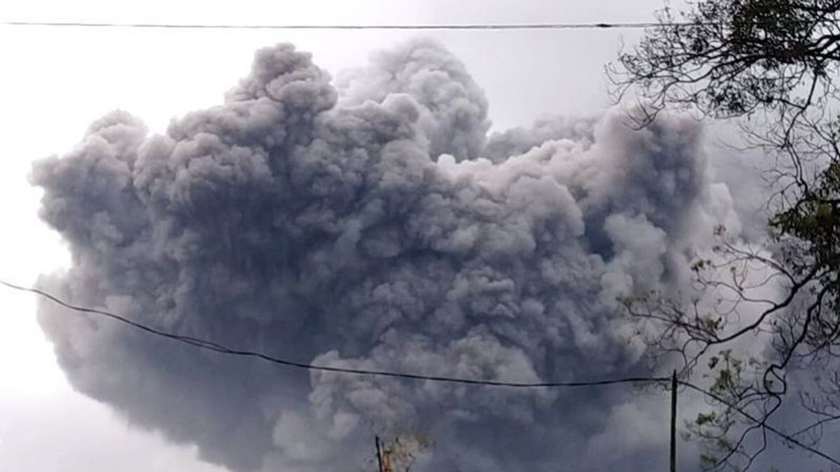
The Mount Semeru Observation Post officer in Poncokusumo Hamlet reported the chronology of the occurrence of hot cloud avalanches from Mount Semeru recorded starting at 14:47 WIB, Saturday, December 4, with a maximum amplitude of 20 mm.
"At 15.10 WIB, the Gunung Sawur Post reported visually that volcanic ash from avalanches of hot clouds was very clearly observed leading to the village of Besuk Kobokan which smelled of sulfur", said Head of BNPB Suharyanto.
Based on records compiled by the Center for Volcanology, said Suharyanto, incandescent lava avalanches were observed 500 to 800 meters with the center of the avalanche approximately 500 meters below the crater.
Mount Semeru or Mount Meru is located in East Java. Mount Semeru, which erupted on December 4, is the highest mountain on the island of Java. The peak of Mount Semeru is Mahameru with a height of 3,676 meters above sea level (masl). Mount Semeru is the third highest after Mount Kerinci in Sumatra and Mount Rinjani in West Nusa Tenggara.
The crater at the top of Mount Semeru is known as Jonggring Saloko. Mount Semeru is located in two regencies, Malang Regency and Lumajang Regency, East Java. This mountain is included in the Bromo Tengger Semeru National Park area.
The English, Chinese, Japanese, Arabic, and French versions are automatically generated by the AI. So there may still be inaccuracies in translating, please always see Indonesian as our main language. (system supported by DigitalSiber.id)


