


JAKARTA - The Meteorology, Climatology and Geophysics Agency (BMKG) reminded the public to be aware of the potential for heavy rain that could be accompanied by lightning and strong winds in a number of areas in Indonesia on Tuesday.
As reported by Antara, Tuesday, November 16, in the pre-warning system, BMKG forecasting areas that have the potential to experience heavy rain accompanied by lightning and strong winds such as Aceh, Bali, Bangka Belitung, Banten, DKI Jakarta, Gorontalo.
Then West Java, East Java, West Kalimantan, South Kalimantan, Central Kalimantan, East Kalimantan, North Kalimantan, Lampung, Maluku.
Then in West Nusa Tenggara, East Nusa Tenggara, Papua, West Papua, Riau, West Sulawesi, South Sulawesi, Central Sulawesi, Sulawesi and Southeast Sulawesi.
Previously, the Head of BMKG Dwikorita Karnawati reminded the public to be aware of the arrival of the La Nina phenomenon towards the end of this year.
Based on monitoring the latest developments of sea surface temperature data in the Pacific Ocean, in the central and eastern parts, shows that currently, the value of the anomaly has crossed the threshold of La Nina, which is -0.61 on the First Basis of October 2021.
This condition has the potential to continue to develop and the community and the government must immediately prepare for the presence of La Nina which is predicted to take place, with light intensity to moderate intensity until February 2022.
SEE ALSO:
-
 | BERITA
Prakiraan Cuaca BMKG: Hujan Landa Jakarta Sejak Siang hingga Malam Ini
15 November 2021, 07:49 -
 | BERITA
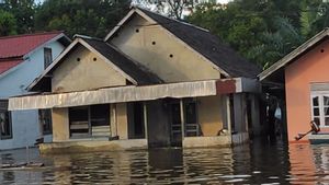
Banjir di Sekadau Kalbar Setinggi 3,1 Meter Ternyata Sudah Berlangsung 2 Minggu Lebih
13 November 2021, 15:10 -
 | BERITA
Prakiraan Cuaca BMKG: Hujan Dominasi Wilayah Sumatera, Kalimantan dan Jawa
12 November 2021, 08:58 -
 | BERITA
Prakiraan Cuaca BMKG: DKI Jakarta Diprakirakan Berawan, Kamis 11 November
11 November 2021, 07:37
Based on the La Nina incident in 2020, the results of the BMKG study show that rainfall has increased from November to January, especially in the areas of South Sumatra, Java, Bali, NTT, South Kalimantan, and South Sulawesi.
"With the potential for an increase in rainfall during the rainy season, it is necessary to be alert and prepared for the potential for continued high rainfall which has the potential to trigger a hydrometeorological disaster," said Dwikorita.
Meanwhile, the Head of the BMKG A Public Meteorology Center, Fachri Radjab, reported that the latest development of sea surface temperature data in the central and eastern Pacific Ocean showed an anomaly value of -0.99 in Dasarian I November 2021.
This shows that the La Nina phenomenon with a weak category is taking place.
"The intensity of La Nina is shown by the anomaly of sea surface temperature in the East Pacific Ocean in a simple way, the impact of a weak La Nina can also increase the potential for rain with moderate to heavy intensity," said Fachri.
The English, Chinese, Japanese, Arabic, and French versions are automatically generated by the AI. So there may still be inaccuracies in translating, please always see Indonesian as our main language. (system supported by DigitalSiber.id)


