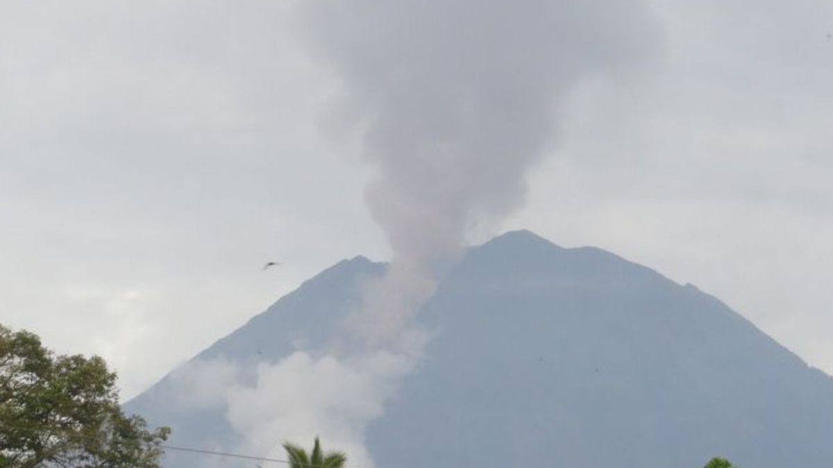


Mount Semeru, which is located on the border of Lumajang and Malang regencies, East Java, recorded 45 eruptions / eruptions for six hours on Friday at 00.00-06.00 WIB.
"For seismic observations, 45 earthquakes were recorded with an amplitude of 10-22 mm and an earthquake of 58-184 seconds," said Mount Semeru Observation Post Officer Rudra Wibowo in a written report received in Lumajang, Friday, November 21.
In addition to the eruption, Mount Semeru also recorded six avalanches with an amplitude of 2-4 mm and a long earthquake of 40-74 seconds, then eight earthquake gusts with an amplitude of 2-4 mm, and an earthquake of 34-69 seconds.
"The Semeru also experienced five distant tectonic earthquakes with an amplitude of 4-8 mm, an S-P of 14-16 seconds and an earthquake length of 25-53 seconds," he said.
He said the visual observations of Mount Semeru were clearly visible until it was covered by 0-III fog and the crater smoke was not observed, and the weather was cloudy to the rain, weak winds to the southeast.
Rudra explained that the status of Mount Semeru at Level IV or Alert, so that the Center for Volcanology and Geological Hazard Mitigation (PVMBG) provided a number of recommendations, namely that people should not carry out any activities in the southeast sector along Besuk Kobokan, as far as 20 km from the summit (the center of the eruption).
Beyond that distance, people are not allowed to carry out activities at a distance of 500 meters from the riverbank (river border) along Besuk Kobokan because it has the potential to be affected by the expansion of hot clouds and lava flows.
SEE ALSO:
-
 | BERITA
Harga Ayam dan Telur Mulai Naik, Pemerintah Lakukan Penyesuaian Menu MBG
21 November 2025, 08:06 -
 | MEMORI
Kontroversi IKN: Kala Jokowi Berikan HGU hingga 190 Tahun ke Investor
21 November 2025, 07:00
"People are also prohibited from doing activities within a radius of 8 kilometers from the crater/peak of Mount Semeru because they are prone to the danger of throwing stones (lightning)," he said.
In addition, it is necessary to be aware of the potential for hot clouds, lava avalanches, and lahars along rivers/valleys that originate at the peak of the Semeru Volcano, especially along Besuk Kobokan, Besuk Bang, Besuk Kembar, and Besuk Sat as well as the potential for lahars in small rivers which are tributaries of Besuk Kobokan.
The English, Chinese, Japanese, Arabic, and French versions are automatically generated by the AI. So there may still be inaccuracies in translating, please always see Indonesian as our main language. (system supported by DigitalSiber.id)
Most Popular Tags
#Prabowo Subianto #donald trump #2026 World Cup #venezuela #konflik timur tengahPopular


