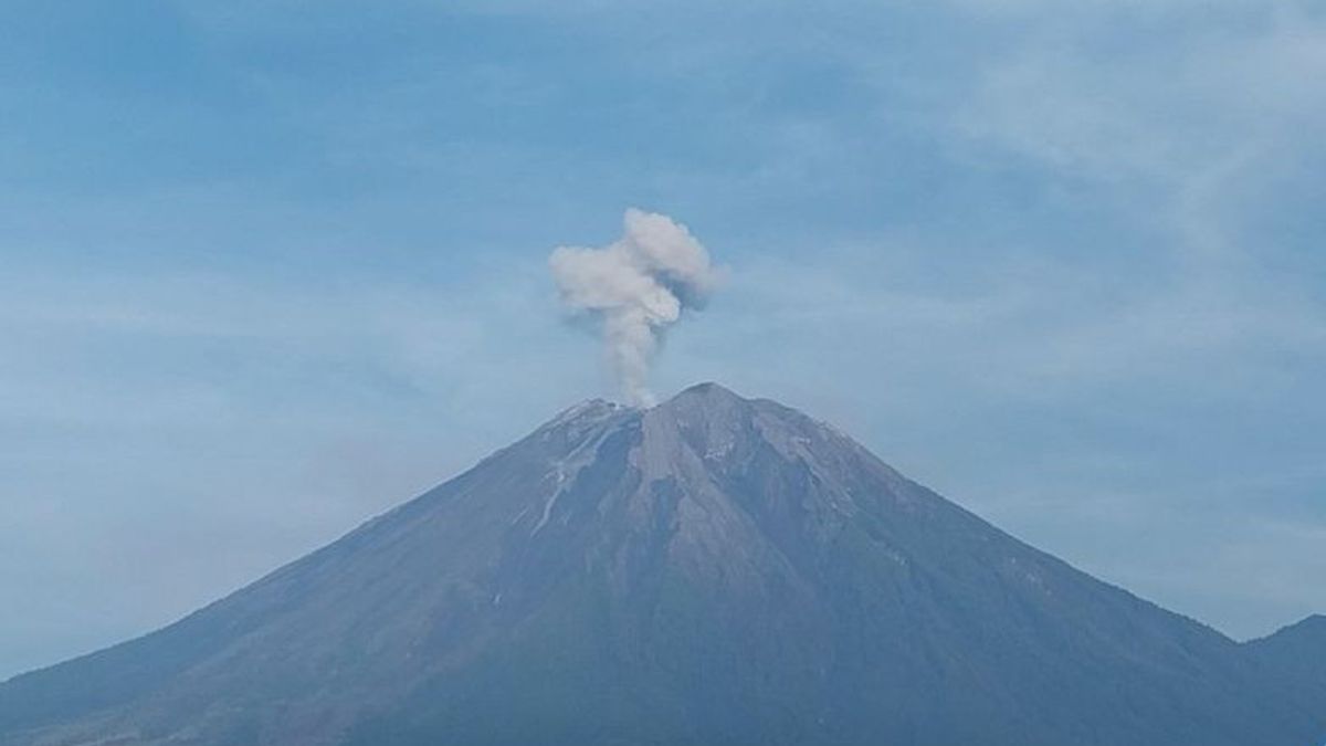


JAKARTA - Mount Semeru Observation Post officers recorded eight eruptions of Mount Semeru with an eruption height of 400 meters to 800 meters above the peak on Thursday, October 30 for six hours from 00.09-06.02 WIB.
"The eruption of Mount Semeru for the first time occurred at 00.09 WIB with an eruption column height of about 600 meters above the peak and a column of ash was observed to be white to gray with moderate to southwest intensity," said Mount Semeru Observation Post Officer Liswanto in a written report received in Lumajang, Thursday, October 30, confiscated by Antara.
The second eruption occurred at 00.14 WIB with an eruption column height of 600 meters above the peak and not long after 00.57 WIB there was a third eruption with an eruption height of 600 meters above the peak and a column of ash white to gray with moderate intensity to the southwest.
At 01.05 WIB, the highest mountain on the island of Java erupted again with an eruption column height of about 700 meters above the peak and erupted again at 04.56 WIB with an eruptive column height observed 400 meters above the peak.
"There was an eruption of Semeru at 05.06 WIB with an eruption column height of about 700 m above the peak. The ash column was observed to be white to gray with moderate to southwest intensity. When the report was made, the eruption was still ongoing," he said.
The height of the eruption column of Mount Semeru is getting higher, reaching 800 meters above the peak of the seventh eruption, precisely at 05.41 WIB. The ash column was observed to be white to gray with moderate intensity to the south.
After 21 minutes, the mountain, which is on the border of Lumajang and Malang Regencies, East Java, erupted again at 06.02 WIB, but the height of the eruption column decreased to 700 meters above the peak.
"The ash column was observed to be gray with thick intensity to the west. This eruption was recorded on a seismograph with a maximum amplitude of 22 mm and a duration of 208 seconds," he said.
Liswanto explained that Mount Semeru is still on Alert or Level II status, so that the Center for Volcanology and Geological Hazard Mitigation (PVMBG) provides a number of recommendations, namely that people are prohibited from carrying out any activity in the southeast sector, along Besuk Kobokan as far as eight kilometers from the summit (the center of the eruption).
Outside of that distance, he said, people are not allowed to carry out activities at a distance of 500 meters from the riverbank along Besuk Kobokan, because it has the potential to be affected by the expansion of hot clouds and lava flows up to a distance of 13 kilometers from the summit.
"People are also advised not to move within a three-kilometer radius of the crater or peak of Mount Semeru, because it is prone to the dangers of incandescent stones," he said.
SEE ALSO:
-
 | BERITA
Demo Guru Madrasah di Monas, Polisi Kerahkan 1.597 Personel Pengamanan
30 Oktober 2025, 07:46 -
 | BERITA
Buka Wacana Jaklingko Diperluas ke Bodetabek, Pramono: Tapi Mungkin 5 Tahun Lagi
29 Oktober 2025, 12:26 -
 | BERITA
Jerman Kucurkan Rp17 Triliun untuk Penyintas Holocaust, 1 Orang Dapat Rp28 Juta
29 Oktober 2025, 13:23 -
 | BERITA
Belarus Anggap Lituania Negara Eropa Kecil Berlebihan Tanggapi Balon Rokok Selundupan
29 Oktober 2025, 11:44
He appealed to the public to be aware of the potential for hot clouds, lava avalanches, and rain lava along rivers/valleys whose water flows originate at the top of Mount Semeru, especially along Besuk Kobokan, Besuk Bang, Besuk Kembar, and Besuk Sat, as well as the potential for lava in small rivers which are tributaries from Besuk Kobokan.
The English, Chinese, Japanese, Arabic, and French versions are automatically generated by the AI. So there may still be inaccuracies in translating, please always see Indonesian as our main language. (system supported by DigitalSiber.id)


