

According to Hasan, the stipulation of land ownership certificates (SHM) affected by abrasion could trigger conflict in the community. According to him, wisdom is needed from various parties, especially the Ministry of ATR/BPN.
Hasan gave an example, there are ponds belonging to residents whose land is quite large, suddenly they have to be destroyed by sea abrasion. Then, the land and rights were also deleted in an instant due to abrasion.
"If the owner wants to use it, that's okay. That means, the certificate is still alive. But it's covered in water, that's okay. It's okay. It's okay if it's canceled without the granting of priority rights, it's definitely a conflict," Hasan told reporters, Monday, February 3.
Hasan emphasized that in Government Regulation Number 18 of 2021 concerning Management Rights, Land Rights, Flats Units, and Land Registration, there are rules for reviving priority rights to land owners affected by abrasion.
So, he views, the government has the potential to be wrong in deciding the status of the land and that the risk is quite heavy.
"If you don't give priority rights to the owner, you will definitely conflict. A lawsuit can appear to the state administrative court. I think it's just a matter of what the facts are. What are the legal rules like. Just follow them. Be safe," said Prof. Nur Hasan.
Previously, the Minister of ATR/Head of BPN, Nusron Wahid, said that the land certificate that was affected by sea abrasion would be reviewed for its certificate status.
"Relying on the abrasion it is permanent or temporary," said Nusron on Thursday, January 30
Nusron said, if land or land is affected by abrasion, it is permanent, the Ministry of ATR/BPN will cancel the ownership status. Vice versa.
"If it's due to temporary flooding, it's temporary. But if it's permanent abrasion, then we cancel it (SHM)," he said.
The reason for the cancellation of SHM, he said, given the fact that land material or land land had disappeared due to sea water abrasion. "It's like a flood of roads, submerged rice fields and then lost water, yes it can still be done," added Nusron.
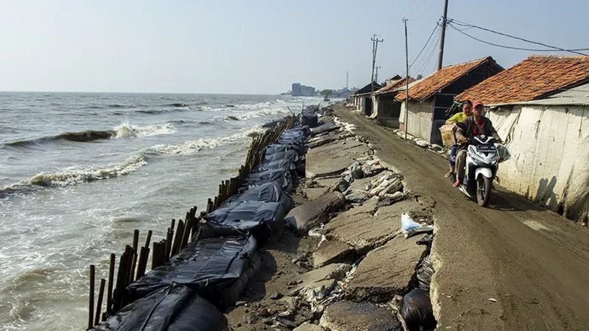
Sekadar informasi, ancaman abrasi di pantai utara Pulau Jawa sudah masuk kategori mengkhawatirkan. Berdasarkan data Kementerian Kelautan dan Perikanan (KKP) yang dikeluarkan pada 2015, sedikitnya 400 kilometer garis pantai di Indonesia, tergerus abrasi.
SEE ALSO:
-
 | BERITA
Kejadian Luar Biasa Demam Berdarah Berlaku di Dompu NTB Buntut 2 Anak Meninggal
03 Februari 2025, 04:14 -
 | EKONOMI
Khawatiran Keamanan Data: Perusahaan Global Blokir Akses ke Chatbot AI DeepSeek Asal China
03 Februari 2025, 05:06 -
 | TEKNOLOGI
Taiwan Larang Penggunaan DeepSeek di Instansi Pemerintah karena Kekhawatiran Keamanan
03 Februari 2025, 06:05
SEE ALSO:
-
| BERITA
Kejadian Luar Biasa Demam Berdarah Berlaku di Dompu NTB Buntut 2 Anak Meninggal
03 Februari 2025, 04:14 -
| EKONOMI
Khawatiran Keamanan Data: Perusahaan Global Blokir Akses ke Chatbot AI DeepSeek Asal China
03 Februari 2025, 05:06 -
| TEKNOLOGI
Taiwan Larang Penggunaan DeepSeek di Instansi Pemerintah karena Kekhawatiran Keamanan
03 Februari 2025, 06:05
Based on the journal Department of Geography of the University of Indonesia (UI) entitled 'Monitoring Changes in Coastal Lines for Evaluation of Spatial Planning and Disaster Management in Tangerang Regency', it shows that all villages on the coast of Tangerang Regency, have been rolled up with abrasion, or accretion in the last 10 years.
The English, Chinese, Japanese, Arabic, and French versions are automatically generated by the AI. So there may still be inaccuracies in translating, please always see Indonesian as our main language. (system supported by DigitalSiber.id)
Most Popular Tags
#Prabowo Subianto #donald trump #2026 World Cup #venezuela #konflik timur tengahPopular


