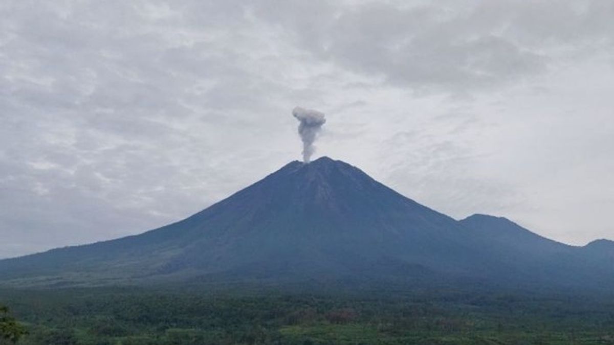


JAKARTA - Mount Semeru was recorded several times as an eruption by vomiting up an eruption reaching 800 meters-1 kilometers (km) from the summit on Tuesday, January 28.
The first eruption occurred at 06.21 WIB with an eruptive column height of about 1,000 meters or 1 km above the peak or 4,676 meters above sea level (masl).
"The ash column was observed to be white to gray with thick intensity to the east and southeast. The eruption was recorded on a seismograph with a maximum amplitude of 21 mm and a duration of 181 seconds," said Mount Semeru Observation Post Officer Sigit Rian Alfian, in a written report received in Lumajang, East Java, Tuesday, January 28, confiscated by Antara.
The second eruption occurred at 07.11 WIB with an eruptive column height of about 800 meters above the peak and a column of ash was observed gray with thick intensity to the northeast. The eruption was recorded on the seismograph with a maximum amplitude of 21 mm and a duration of 124 seconds.
A few minutes later or to be precise at 07.35 WIB, the highest mountain on the island of Java erupted again with an eruption height observed about 800 meters above the peak.
"The ash column was observed to be gray with thick intensity to the northeast and east. This eruption was recorded on a seismograph with a maximum amplitude of 22 mm and a duration of 119 seconds," he said.
Then at 08.48 WIB there was another eruption with an eruptive column height of about 800 meters above the peak and a gray column of ash was observed with thick intensity to the northeast and east, and the eruption was recorded on the seismograph with a maximum amplitude of 22 mm and a duration of 110 seconds.
"The Semeru Monument erupted again at 10.28 WIB and the eruption visual was not observed, but the eruption was recorded on a seismograph with a maximum amplitude of 22 mm and a duration of 123 seconds," he said.
SEE ALSO:
-
 | BERITA
Prabowo Perintahkan Efisiensi Anggaran, Pemprov DKI Buka Opsi Kurangi Hibah untuk Ormas
28 Januari 2025, 10:42


Sigit explained that Mount Semeru is still on Alert status, so the Center for Volcanology and Geological Hazard Mitigation (PVMBG) provides a number of recommendations, namely that people are prohibited from carrying out any activity in the southeast sector along Besuk Kobokan as far as eight kilometers from the summit (the center of the eruption).
Beyond that distance, he continued, people are not allowed to carry out activities at a distance of 500 meters from the riverbank (river border) along Besuk Kobokan, because it has the potential to be affected by the expansion of hot clouds and lava flows up to a distance of 13 kilometers from the summit.
"People are also not allowed to move within a radius of 3 kilometers from the crater/peak of Mount Semeru, because they are prone to the dangers of throwing incandescent stones," he said.
In addition, he said, the public also needs to be aware of the potential for hot clouds, lava avalanches, and rain lava along rivers/valleys that originate at the top of Mount Semeru, especially along Besuk Kobokan, Besuk Bang, Besuk Kembar, and Besuk Sat, as well as the potential for lava in small rivers that are tributaries from Besuk Kobokan.
The English, Chinese, Japanese, Arabic, and French versions are automatically generated by the AI. So there may still be inaccuracies in translating, please always see Indonesian as our main language. (system supported by DigitalSiber.id)


