

The Ministry of Transportation (Kemenhub) will arrange a service flow to the Ulee Lheue Port in Aceh.
The move aims to improve security at the time of crossing.
Director of Kenavigasian Budi Mantoro said that it is appropriate for the shipping route to enter Ulee Lheue Port to be determined immediately, to obtain an ideal shipping channel and fulfill various aspects of safety and smooth interests to navigate and protect the sustainability of the maritime environment.
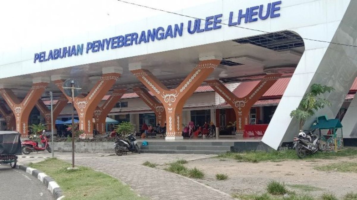
The reason is, Ulee Lheue Port is located in Meuraxa District, Banda Aceh City, approximately 7 km from the Banda Aceh City Center.
This port is a ferry ferry port and fast boat, which is the only sea transportation facility that serves passengers on a shipping route from Banda Aceh-Sabang-Pulo Aceh.
In addition, said Budi, Ulee Lheue Port as a center for passenger activity has a considerable contribution to local economic growth and regional economic development.
"Therefore, it is important for us to ensure that there is an appropriate, safe and efficient shipping flow at Ulee Lheue Port," said Budi, in Jakarta, Wednesday, July 12.
Furthermore, Budi revealed, Ulee Lheue Port currently has an area of approximately 8 hectares including passenger terminal facilities as the main building, parking lot, fast boat dock, slow boat dock, port pool and others.
"In the revision of the 2006-2016 Banda Aceh City RTRW, it is explained that the development of ports in the old Port of the Ulee Lheue Area is for internationally scale ports, as primary feeder ports and functions for public ports serving inter-island and state passengers," he explained.
Budi said, this port also functions as a gateway for the provinces, districts, and surrounding cities.
"This port will be intended primarily for passenger ships from and to the Balohan Port in Sabang," Budi said.
Related to this, Budi added, the Directorate General of Sea Transportation through the Sabang Class II Type A Navigation District in collaboration with Pushidrosal has conducted an independent survey to develop a plan to determine the entry route for Ulee Lheue Port.
Based on the survey results, technically the Ulee Lheue Port has a length flow of 2.5 km (1.39 Nm), a width of 60 m (break water) and a depth of 1.17 to 12.37 mLWS. The results of the survey in the Port pool are found to be in depths ranging from 1.22 to 4.72 meters with the type of sand sea bottom material and smooth mud.
Ulee Lheue Port has 7 SBNP existings, has a one-way route system and there is a PKA 5 SROP Ulee Lheue Station. The flow design is not in a conservation area and there are no mine areas, pipes and submarine cables.
"The survey results recommend carrying out dredging in areas where there are silts around the port pool and the entrance to the Ulee Lheue Port shipping lane so that the ship moves safely," said Budi.
Socialization
In addition, Budi said, the pandemic for the realization of safe and comfortable shipping entry flow needs to be carried out socialization for shipping entry service users, such as fishing boats by fishing stakeholders and it is also necessary to propose an installed Indonesian Suar List (DSI).
Budi hopes that with the stipulation of the Ulee Lheue Port Shipping Lane, it will not only guarantee the safety of ships on the Ulee Lheue Port Entrance Shipping Lane so that the smooth traffic can increase.
另请阅读:
-
 | EKONOMI
Tarif LRT Jabodebek Ditetapkan Mulai dari Rp5.000 untuk Kilometer Pertama
10 Juli 2023, 21:31
However, Budi said, it can also preserve the maritime environment along the waters of the Shipping Lane, support maritime service users in the form of PLI (Electricity/Electronics) and Pushidrosal Nautika products, increase the intensity, effectiveness and connectivity of Shipping and smooth flow of goods and passengers, and emphasize the use of marine spatial planning so that the management and utilization of marine space are in harmony.
For this reason, Budi hopes that experts, stakeholders, and maritime experts can share their knowledge, experience, and views regarding the plan to determine the Ulee Lheue Port Entrance Shipping Path.
The English, Chinese, Japanese, Arabic, and French versions are automatically generated by the AI. So there may still be inaccuracies in translating, please always see Indonesian as our main language. (system supported by DigitalSiber.id)