

JAKARTA - If you can't wait for billionaire Elon Musk's plans to bring humans to Mars, you can first get to know and explore the planet with interactive maps.
Created by researchers from Freie Universität Berlin, Sebastian Walter and colleagues, an interactive map showing Mars Crater based on NASA's robotic rover data, Perseverance allows users to circle around the planet's surface and follow the path of the rover robot.
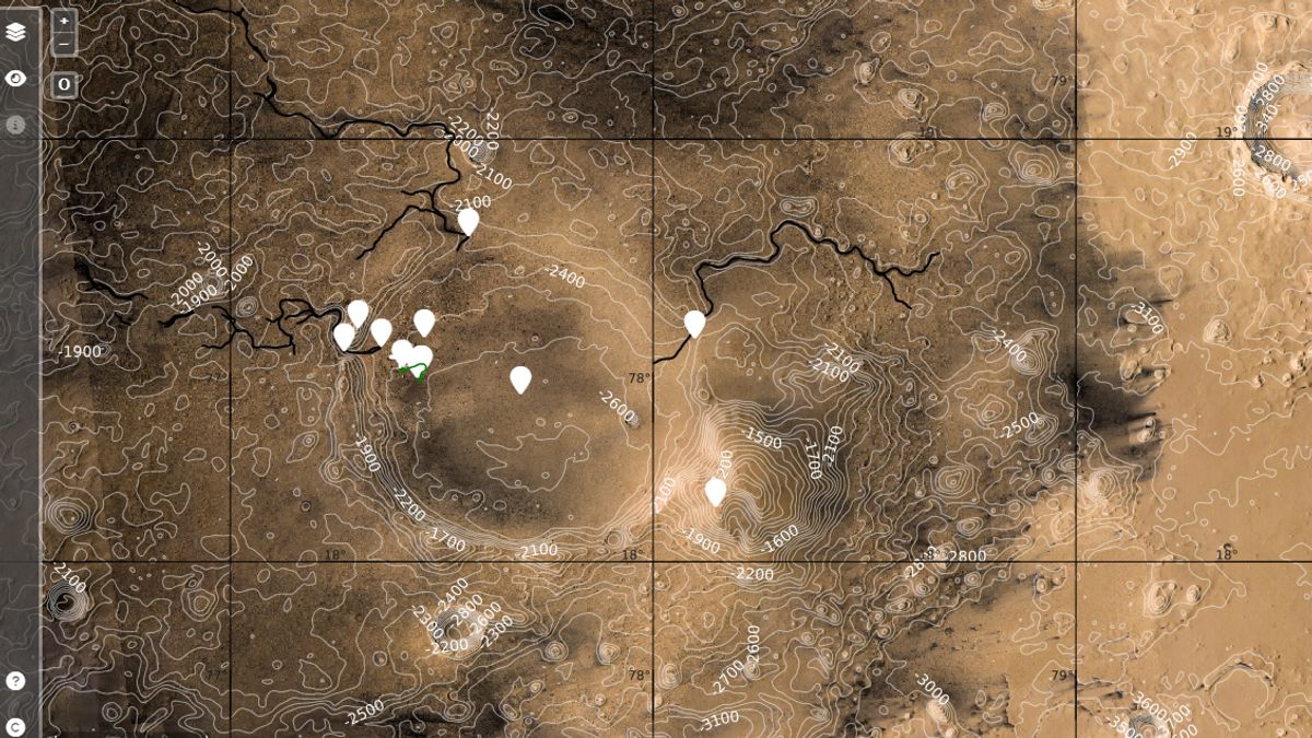
Introduced at the Europlanet Science Congress 2022, the map will show data such as topography, contour lines, and the path of the rover robot as well as the current position inside the crater.
There is also a benchmarked panoramic view so that users can zoom in and enjoy 360-degree views of Planet Mars.
This map is the perfect tool for planning future visits to Mars, with interactive interfaces where you can choose from the various basic datasets available, Walter said in a statement quoted from Digital Trends, Monday, September 26.
Some slopes are quite steep, so be careful if you want to avoid consuming too much oxygen! To experience what your future Mars journey expects, you can click on one of the signposts to enter the full-screen 3D view or, if you have Virtual Reality (VR) settings, to enter a fully immersive environment. You can even listen to the sound of the rover if you stand nearby," he added.
Walter added that the data from the map is a combination recorded by Perseverance. Where the Mastcam-Z camera works to capture images and SuperCam instruments capture the sound of the Red Planet.
Both data, said Walter formed a basic layer of the map. He got it from the European Space Agency (ESA) Mars Express and NASA Mars Reconnaissance Orbiter, both of which were used to capture high-resolution surface images.
Initially, Walter said the map was designed only for professional scientists, but when he and his colleagues added a lot of data, they realized this map would be nice if accessed by the public.
Initially we created the Jazero map as an outreach application to complement Mapserver's HRSC tools, which supports professional scientists to explore the Martian surface, said Walter. But because the rover returned more high-resolution image data and even audio recordings, it turned out to be the perfect tool for deep visualization of the data in the scientific context of itself, he added.
The English, Chinese, Japanese, Arabic, and French versions are automatically generated by the AI. So there may still be inaccuracies in translating, please always see Indonesian as our main language. (system supported by DigitalSiber.id)
Tags les plus populaires
#Prabowo Subianto #Nouvel An #pdip #Hasto Kristiyanto #nataru #NatalPopulaire