

JAKARTA - Google Maps Street View turns 15 years old and Google is marking the celebration by launching new features and cameras that will bring more of the world to users.
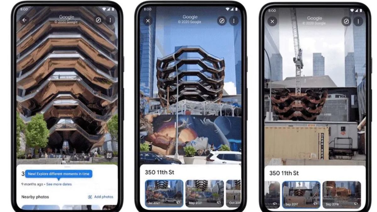
One of the features it brings is Street View historical imagery for iOS and Android applications. Back in 2014, desktop users were first able to use Google Maps' Street View to go back in time, giving them the ability to view old images of their city or home.
When in Street View mode, users can access historical imagery by first tapping anywhere on the photo to view information about the location, then selecting view other dates to access historical imagery of the current location.
Google says the feature has been able to display imagery since the launch of Street View in 2007, although the locations available at the time were limited, and this time it was debuting in a mobile app.
Street View for mobile users will first launch in New York, Las Vegas, San Francisco, Denver and Miami, so these places will have the oldest historical data.
In addition, Google also announced that it will use a new camera next year to capture more high-quality images in more difficult-to-reach places.
"This new camera takes all the power, resolution, and processing capabilities we've built into the whole Street View car, and shrinks it into an ultra-transport camera system that's roughly the size of a house cat," Google said in a blog post on Wednesday, May 25.
"But unlike the domestic cat, it is ready to be taken to remote islands, to the tops of mountains or for walks in the local town square."
The new camera weighs less than 15 pounds, can be shipped anywhere, and is designed to be modular so components such as lidar can be added to collect images with more useful details, such as path marks or holes.
Furthermore, the camera can also be attached to any vehicle with a roof rack and operated via a mobile device.
"You'll start seeing our new camera in fun Google colors alongside our iconic Street View cars and trekkers next year," Google said.
Street View imagery also supports Live View, a feature where users can use the phone's camera to view arrows, directions, and distance markers placed directly above the real world.
The launch later this year also brings the previously announced Immersive view, combining billions of Street Views and aerial images to create digital models of places around the world.
VOIR éGALEMENT:


Immersive view uses artificial intelligence and high-quality 3D rendering to simulate real-time data.
Finally, Google added four new collections of places such as the Pyramid of Mero in Sudan, The Duomo in Milan, Les Invalides in Paris, and Sydney Ferries in Australia.
The Pyramid of Meroë showcases new panoramic images of the ancient pyramids, while the Duomo showcases the inside and outside of Italy's largest cathedral. There is a virtual Les Invalides tour available in Paris, and Sydney Ferries in Australia is coming later this year along with a virtual tour of its own.
The English, Chinese, Japanese, Arabic, and French versions are automatically generated by the AI. So there may still be inaccuracies in translating, please always see Indonesian as our main language. (system supported by DigitalSiber.id)
Tags les plus populaires
#Prabowo Subianto #Golkar #élections jakarta #jeux d’argent en ligne #Mount Lewotobi malePopulaire