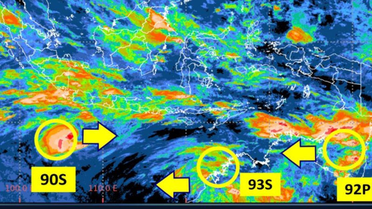


JAKARTA - The Meteorology, Climatology and Geophysics Agency (BMKG) urges the public to be aware of the potential for moderate to heavy rain in Central Java as an indirect impact of Tropical Cyclone 90S, which is monitored in the southern Indian Ocean, Banten-Jabar.
The Head of the BMKG Data and Information Dissemination Service Working Team at the Tunggul Wulung Cilacap Meteorological Station, Teguh Wardoyo, explained that based on the BMKG update on Tuesday morning at 07.00 WIB, the circulation of Tropical Cyclone 90S Seed increased the supply of water vapor to the southern region of Java Island, including Central Java.
"Although the chance of becoming a tropical cyclone is low, this system still has an impact on increasing the growth of rain clouds in Central Java," he said.
He predicted that moderate to heavy rain could occur gradually, especially in the southern region, highlands, and mountainous areas.
According to him, this condition is at risk of triggering hydrometeorological disasters such as floods, waterlogging, and landslides, especially in areas with steep topography and less optimal drainage systems.
In addition to rain, he said, the public was also asked to be aware of the increased wave height in the southern waters of Central Java.
In fact, the wave height in the southern Indian Ocean of Java has the potential to reach 2.5-4 meters, which can endanger the safety of navigation, especially for fishing boats and small-sized ships.
"Fishermen and shipping service operators should pay attention to maritime weather forecast information before going to sea and prioritize safety," he said.
In addition to 90S, there are two other tropical cyclone seedlings that are also monitored, namely 92P around the Gulf of Carpentaria and 93S in the northwest of Australia.
According to him, both systems also have a low chance of becoming tropical cyclones, but can affect wave conditions in a number of waters in eastern and southern Indonesia.
"The Tropical Cyclone 92P seed has an impact on increasing waves in the Arafuru Sea, while the Tropical Cyclone 93S seed contributes to high waves in the Sawu Sea and the southern Indian Ocean of Nusa Tenggara," he said.
Although the direct impact on the Central Java region is more dominant triggered by Tropical Cyclone 90S, he said the existence of the three systems indicates a fairly active atmospheric dynamics in the Indonesian region.
According to him, the weather conditions triggered by the three systems are expected to last until Wednesday (4/3) at 07.00 WIB.
"We appeal to the public to remain calm but vigilant and continue to monitor the development of official weather information to anticipate the potential impact of extreme weather in the Central Java region," said Teguh.
The English, Chinese, Japanese, Arabic, and French versions are automatically generated by the AI. So there may still be inaccuracies in translating, please always see Indonesian as our main language. (system supported by DigitalSiber.id)


