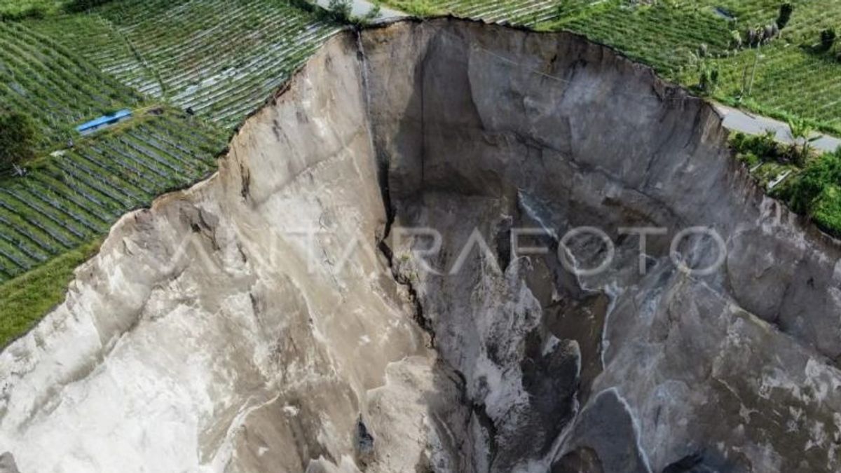


BANDA ACEH - The Aceh Energy and Mineral Resources Agency (ESDM) has recorded that the phenomenon of movement or landslides in Bah Village, Ketol District, Central Aceh Regency, continues to grow to more than 30 thousand square meters (m²).
"For the current area, we have calculated that it is above 30,000 m². If 2021 is still 20,199 m², so there is an addition of more than 10,000 m²," said the Head of Geology and Groundwater of the Aceh ESDM Office, Ikhlas, as reported by ANTARA, Tuesday, February 3.
Ikhlas emphasized that the landslide was not a sinkhole, but a phenomenon of subsurface erosion (piping erosion) caused by erosion by groundwater and surface water, as well as due to steep cliff conditions and can be triggered by earthquakes and rain.
On the other hand, he said, the Geological Agency of the Ministry of Energy and Mineral Resources is also carrying out a study to update the data and from the initial analysis it can be concluded that the phenomenon is not a sinkhole.
"The Geological Agency has stated that it is not a sinkhole, but rather piping erosion or bamboo erosion/erosion below the surface," he said.
Ikhlas said the Aceh ESDM Service had recently also returned to the location of the landslide and had received several notes that needed to be followed up.
Based on the results of the interim study, he said, the movement of the land there was caused by the material being arranged on top of volcanic tuff from the Geureudong formation (volcanic rock) which is loose, porous, so it is easy to absorb water and water saturated.
Then, there is a discharge or underground water flow that erodes laterally. The drainage channel can overflow and burden the soil there, especially when the rainy season comes.
"The steep, almost vertical cliff condition adds to the instability of the slope, and can be triggered by rain and also earthquakes, so the slope is unstable," he said.
Regarding this condition, his party appealed to all parties concerned, especially the government elements, to carry out socialization to the public about the vulnerability of subsequent landslides, not to approach the landslide area, especially during the rainy season due to slope instability.
Then the Central Aceh Regency Government (Pemkab) can relocate the road to a safer area, move the drainage that can burden the land in the landslide area, so that it does not make the land move quickly.
On the other hand, Ikhlas said, it is also necessary to conduct a geological engineering study for the construction of infrastructure in the new area, including structural mitigation (cliff planting, cliff reinforcement / support, and drainage arrangement).
Furthermore, strengthening non-structural mitigation such as education, disaster socialization is very necessary, and to the public so that they can follow the local government's directions regarding the landslide disaster.
"Finally, it must be monitored periodically, especially if new cracks are found to be extending and widening, and immediately reported to the relevant agencies," said Ikhlas.
For information, based on reports from various sources, the BPBD Central Aceh, the land landslide started in the form of a small hole since the early 2000s, and has continued to move gradually since 2004.
From reports from the surrounding community, in 2006 the landslide had cut off the Blang Mancung-Simpang Balik road access (connecting Central Aceh Regency - Bener Meriah).
Even there was a relocation of people's residence in Kampung Bah Serempah to Kampung Serempah Baru in 2013-2014. Rehabilitation and reconstruction were carried out in three stages during that period.
The English, Chinese, Japanese, Arabic, and French versions are automatically generated by the AI. So there may still be inaccuracies in translating, please always see Indonesian as our main language. (system supported by DigitalSiber.id)


