

The Geological Agency of the Ministry of Energy and Mineral Resources (ESDM) issued safety recommendations following the eruption that occurred on Mount Semeru, East Java and Mount Dukono in North Maluku this Friday morning.
Officers from the Geological Agency of the Mount Dukono Observation Post, Bambang Sugiono, in his statement in Jakarta, Friday, stated that the eruption occurred at 08.01 WIT with an eruptive column height of about 1,400 meters above the peak or 2,487 meters above sea level.
The ash column from the Dukono eruption was observed to be white to gray with thick intensity to the northwest. When this report was published, the eruption activity was still ongoing.
The Geological Agency recommends that the community, climbers and tourists do not carry out activities within a 4 kilometer radius of the Maupang Warirang Crater, the eruption center of Mount Dukono.
"Given that the eruption of volcanic ash in Dukono occurs periodically and the distribution depends on the direction and speed of the wind, the community is advised to always provide masks or nasal and mouth coverings," he said, as reported by ANTARA.
SEE ALSO:
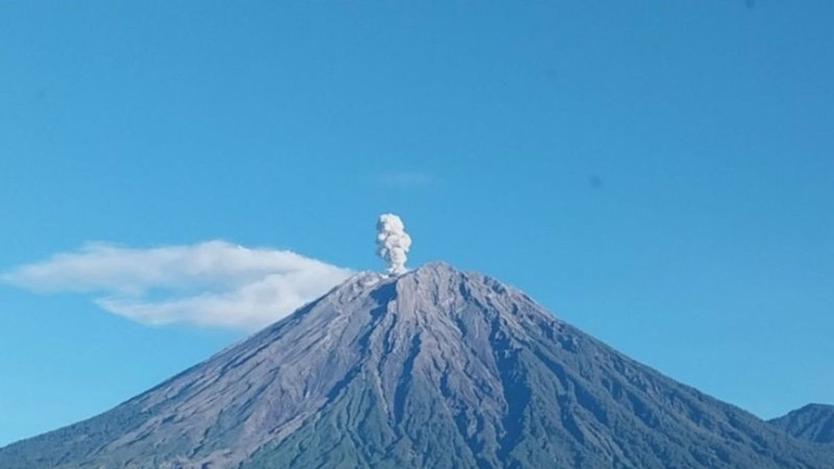
Meanwhile, Mount Semeru on the border of Lumajang and Malang Regencies, East Java also experienced an eruption at 06.35 WIB with an eruption column about 500 meters high from the peak or 4,176 meters above sea level.
Officer from the Geological Agency of the Mount Semeru Observation Post, Mukdas Sofian, said that the ash column was observed to be white to gray towards the southwest with thick intensity.
"The Semeru eruption was recorded on a seismograph with a maximum amplitude of 22 mm and an earthquake duration of 115 seconds," he said.
The Geological Agency warned the public not to move as far as 8 kilometers from the eruption center along Besuk Kobokan, as well as to avoid river borderes as far as 500 meters outside the radius.
In addition, the public is also advised not to enter an area within a radius of 3 kilometers from the crater because of the potential for incandescent stones. Residents around the river that originates at the peak of Semeru are asked to be aware of the potential for hot clouds, lava avalanches, and lahars, especially in Besuk Kobokan, Besuk Bang, Besuk Kembar and Besuk Sat.
The Geological Agency ensures that it will continue to monitor the development of the activities of these two mountains and will also update information and recommendations according to conditions in the field.
The English, Chinese, Japanese, Arabic, and French versions are automatically generated by the AI. So there may still be inaccuracies in translating, please always see Indonesian as our main language. (system supported by DigitalSiber.id)
Most Popular Tags
#Prabowo Subianto #donald trump #2026 World Cup #Febrie Adriansyah #8791Popular


