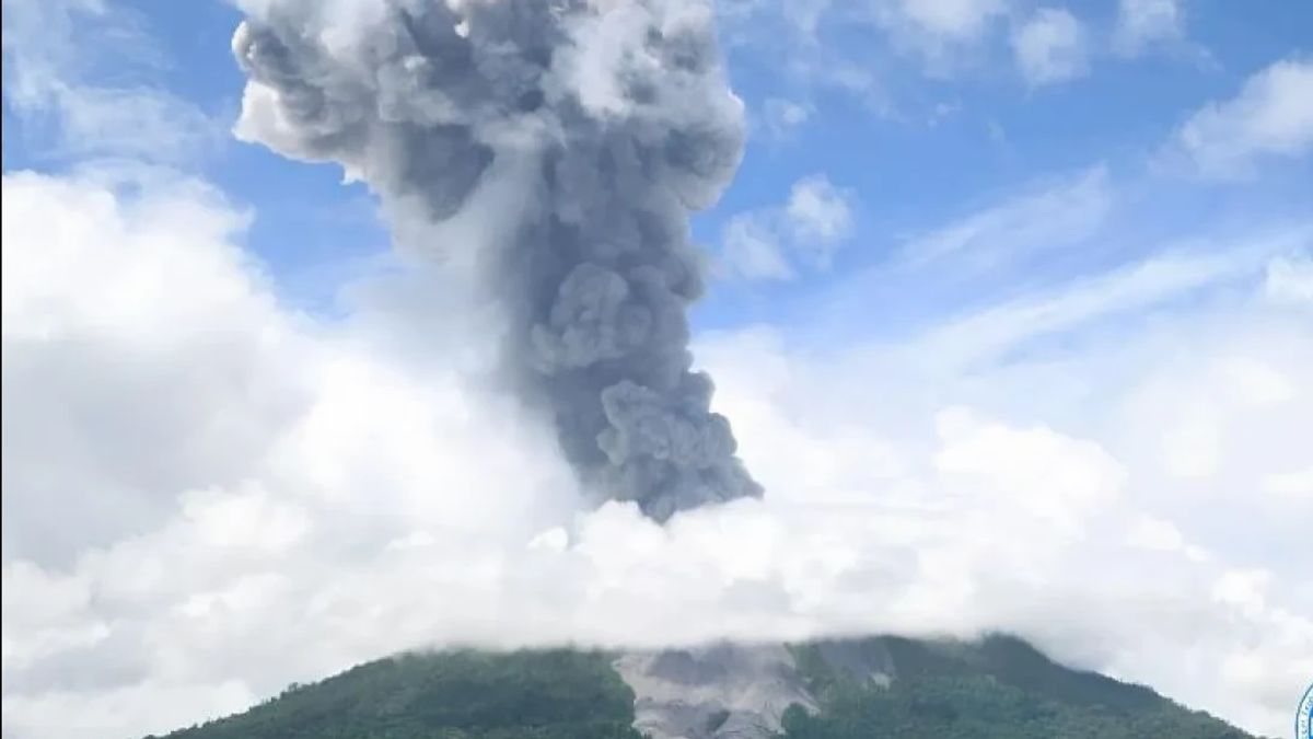
The Geological Agency of the Ministry of Energy and Mineral Resources (ESDM) has set a danger zone or prohibition for people to move in line with the increase in volcanic eruptions of Mount Ibu, West Halmahera, North Maluku at a radius of 6 kilometers from the direction of the active crater.
"Until now, we have set recommendations so that there is no activity within the sectoral expansion radius 6 kilometers to the active crater north of Mount Ibu," said Head of the Geological Agency of the Ministry of Energy and Mineral Resources Muhammad Wafid as reported by ANTARA, Wednesday, January 15.
Wafid explained the recommendation for a ban on activity at a radius of 6 kilometers north as a hazard zone because based on observations it is the direction of the active crater opening of the volcanic eruption with a height of 1,340 meters above sea level (masl).
The Geological Agency considers this recommendation to be carried out by the community and also supervised by the local government because it is not only to minimize the potential impact caused by the eruption, but also to potential further hazards such as cold lava floods.
"Officers from the Center for Volcanology and Geological Hazard Mitigation (PVMBG) in West Halmahera are fully alert to report any developments in the activities of Mount Ibu," he added.
The status of Mount Ibu activity in West Halmahera, North Maluku has been upgraded from the previous Alert, now to Alert or level IV, on Wednesday afternoon.
The increase in status was carried out after the Geological Agency team detected a significant increase in Mount Ibu's volcanic activity in the period 1-14 January 2025.
SEE ALSO:
Officers at the Gunung Ibu observation post in Gam Ici Village, West Halmahera recorded an eruption incident reaching an average of 70 events per day. In the January 2025 period, the height of the fluctuating eruption column was observed and symptoms of an increase in the height of the eruption column to a maximum of 4 kilometers from above the peak.
In this time range, 748 earthquake eruptions were reported, 70 earthquake avalanches, 1,643 earthquake gusts, 6,976 shallow volcanic earthquakes, 346 deep volcanic earthquakes, 60 local tectonic earthquakes with a dominant amplitude of 3 millimeters.
Meanwhile, based on the results of a field survey by Geological Agency officers together with the National Disaster Management Agency (BNPB), it is estimated that there are as many as 300 thousand to 500 thousand cubic meters of volcanic material that have the potential to overflow when it rains from the opening of the Mount Ibu crater along the river to the plantation area, which has morphologies such as river valleys and hit existing locations.
The results of the analysis and survey also found a number of villages in West Halmahera Regency that should be vigilant, including Sangaji Nyeku Village, Goin, Tokuoko, Dunono, Tuguis, and Togoreba Desa Sungi, because the location of the village is a shear with a river flow from upstream of Mount Ibu.
The English, Chinese, Japanese, Arabic, and French versions are automatically generated by the AI. So there may still be inaccuracies in translating, please always see Indonesian as our main language. (system supported by DigitalSiber.id)


